
Faça uma doação
Mapa topográfico Logan Canyon
Clique no mapa para exibir a altitude.
Faça uma doação
Logan Canyon
Logan Canyon is a canyon in the western United States in northeastern Utah, which cuts its way through the Bear River Mountains, a branch of the Wasatch Range. It is popular for both summer and winter activities, especially rock-climbing, hiking, camping, fishing, snowmobiling, and skiing, at the Beaver Mountain ski resort. The canyon rises to an elevation of approximately 7,800 feet (2,400 m) above sea level, after a vertical climb of about 2,900 feet (880 m). Just beyond the summit is a steep road leading into Bear Lake Valley and scenic overlooks that provide views of deep blue Bear Lake. The western terminus is at Logan in Cache County and the eastern terminus is at Garden City in Rich County.
Faça uma doação
Sobre este mapa
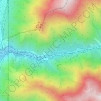
Nome: Mapa topográfico Logan Canyon, altitude, relevo.
Local: Logan Canyon, Cache County, Utah, 84322, United States (41.73367 -111.77968 41.75367 -111.75968)
Altitude média: 1.780 m
Altitude mínima: 1.428 m
Altitude máxima: 2.253 m
Faça uma doação
Outros mapas topográficos
Clique em um mapa para visualizar sua topografia, sua altitude e seu relevo.
Logan
United States > Utah > Cache County
The city lies near the eastern edge of Cache Valley on the western slopes of the Bear River Mountains. Mount Logan rises to an elevation of 9,710 feet (2,960 m) immediately to the east, and south of Logan Canyon. The eastern portions of the city are constructed on top of shelf-like "benches", late Pleistocene…
Altitude média: 1.498 m
Faça uma doação
Faça uma doação
Logan
United States > Utah > Cache County
The city lies near the eastern edge of Cache Valley on the western slopes of the Bear River Mountains. Mount Logan rises to an elevation of 9,710 feet (2,960 m) immediately to the east, and south of Logan Canyon. The eastern portions of the city are atop shelf-like "benches", late Pleistocene sedimentary…
Altitude média: 1.498 m
Faça uma doação