Geolocalizar
👉 Easily get elevation data in JSON, GeoTIFF and KML formats using Elevation API
Obrigado por apoiar este site ❤️
Faça uma doação

Mapa topográfico Wakefield

Clique no mapa para exibir a altitude.

👉 Easily get elevation data in JSON, GeoTIFF and KML formats using Elevation API
Obrigado por apoiar este site ❤️
Faça uma doação

Sobre este mapa

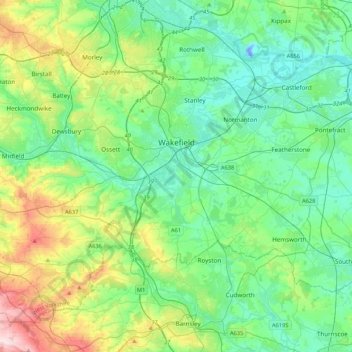
Nome: Mapa topográfico Wakefield, altitude, relevo.

Local: Wakefield, West Yorkshire, England, United Kingdom (53.57535 -1.62490 53.74181 -1.19881)

Altitude média: 88 m

Altitude mínima: -21 m

Altitude máxima: 360 m

Outros mapas topográficos

Clique em um mapa para visualizar sua topografia, sua altitude e seu relevo.

London

United Kingdom > England > London

Altitude média: 42 m

Cambridge

United Kingdom > England > Cambridge

The city, like most of the UK, has a maritime climate highly influenced by the Gulf Stream. Located in the driest region of Britain, Cambridge's rainfall averages around 570 mm (22.44 in) per year, around half the national average, with some years occasionally falling into the semi-arid (under 500 mm (19.69…

Altitude média: 18 m

Leeds

United Kingdom > England

Lying in the eastern foothills of the Pennines, there is a significant variation in elevation within the city's built-up area. The district ranges from 1,115 feet (340 m) in the far west on the slopes of Ilkley Moor to about 33 feet (10 m) where the rivers Aire and Wharfe cross the eastern boundary. Land rises…

Altitude média: 94 m

Orpington

United Kingdom > England > Greater London

Altitude média: 89 m

Bedford

United Kingdom > England > Bedford

As with the rest of the United Kingdom, Bedford has a maritime climate, with a limited range of temperatures, and generally even rainfall throughout the year. The nearest Met Office weather station to Bedford is Bedford (Thurleigh) airport, about 6.5 miles (10.5 km) north of Bedford town centre at an elevation…

Altitude média: 37 m

Hull

United Kingdom > England > Kingston upon Hull

Kingston upon Hull is on the northern bank of the Humber Estuary. The city centre is west of the River Hull and close to the Humber. The city is built upon alluvial and glacial deposits which overlie chalk rocks but the underlying chalk has no influence on the topography. The land within the city is generally…

Altitude média: 21 m

Radcliffe

United Kingdom > England

Altitude média: 94 m

Highgate

United Kingdom > England > Birmingham

Altitude média: 126 m

Broadstairs

United Kingdom > England > Kent > Thanet

Altitude média: 14 m

Harpenden

United Kingdom > England > Harpenden

Altitude média: 120 m

Louth

United Kingdom > England > Louth

Altitude média: 50 m

Epsom

United Kingdom > England > Surrey > Epsom and Ewell

Altitude média: 77 m

West Bromwich

United Kingdom > England > Sandwell

The town's football club is West Bromwich Albion. The club was founded in 1878 and in 1888 it became one of the 12 founder members of the Football League. It won the league championship in 1920 and has won the FA Cup five times, most recently in 1968, and won the League Cup in 1966. Albion were based in and…

Altitude média: 149 m

Plymouth

United Kingdom > England > Devon > Plymouth

The River Plym, which flows off Dartmoor to the north-east, forms a smaller estuary to the east of the city called Cattewater. Plymouth Sound is protected from the sea by the Plymouth Breakwater, in use since 1814. In the Sound is Drake's Island which is seen from Plymouth Hoe, a flat public area on top of…

Altitude média: 81 m

Moreton

United Kingdom > England

Altitude média: 16 m

Ferndown

United Kingdom > England > Dorset

Altitude média: 21 m

Wanstead Flats

United Kingdom > England > London

Altitude média: 20 m

Yeovilton

United Kingdom > England > Somerset

Altitude média: 20 m

Walthamstow

United Kingdom > England

Altitude média: 21 m

Hucknall

United Kingdom > England > Nottinghamshire > Ashfield

Hucknall Airfield, built in 1916, became RAF Hucknall. From 1927, Rolls-Royce began using the airfield for flight tests. During World War II, the aerodrome at Hucknall launched the first flight of a P-51 Mustang fitted with a Rolls-Royce Merlin Engine. The Merlin, replacing the earlier Allison V-1710 engine,…

Altitude média: 104 m

Chard

United Kingdom > England > Somerset

Chard is a town and a civil parish in the English county of Somerset. It lies on the A30 road near the Devon and Dorset borders, 15 miles (24 km) south west of Yeovil. The parish has a population of approximately 13,000 and, at an elevation of 121 metres (397 ft), Chard is the southernmost and one of the…

Altitude média: 135 m

Camberley

United Kingdom > England > Surrey > Surrey Heath

The Staff College, to the north of Camberley town centre, is part of the Joint Services Command and Staff College, which provides training and education for established officers in the British Armed Forces and civil servants in the Ministry of Defence. The institution has its origins in the Royal Military…

Altitude média: 88 m

Beccles

United Kingdom > England > Beccles

Altitude média: 18 m

Hayle

United Kingdom > England > Hayle

Altitude média: 42 m

Reading

United Kingdom > England > Reading

Mary Russell Mitford lived in Reading for a number of years and then spent the rest of her life just outside the town at Three Mile Cross and Swallowfield. The fictional Belford Regis of her eponymous novel, first published in 1835, is largely based on Reading. Described with topographical accuracy, it is…

Altitude média: 56 m

Peterborough

United Kingdom > England > Cambridgeshire

The local topography is flat, and in some places, the land lies below sea level, for example in parts of the Fens to the east and to the south of Peterborough. Human settlement in the area began before the Bronze Age, as can be seen at the Flag Fen archaeological site to the east of the current city centre,…

Altitude média: 17 m

The Mount

United Kingdom > England > Devon > South Hams > Totnes

Altitude média: 70 m

Swincliffe

United Kingdom > England > Kirklees > Birkenshaw

Altitude média: 148 m

Isles of Scilly

United Kingdom > England

Altitude média: 2 m

Huddersfield

United Kingdom > England > Kirklees

Altitude média: 145 m

Wallasey

United Kingdom > England

Wallasey is situated at the north-east of the Wirral Peninsula, on the western side of the River Mersey and adjoining the Irish Sea. The area is approximately 9.5 km (5.9 mi) east-north-east of the Dee Estuary at Hoylake. Wallasey is at an elevation of between 0–50 m (0–164 ft) above sea level, with the…

Altitude média: 12 m

Sudbury

United Kingdom > England > Suffolk > Babergh

Altitude média: 54 m

Portsmouth

United Kingdom > England > Hampshire > Portsmouth

By road, Portsmouth lies 73.5 miles (118.3 km) from Central London, 49.5 miles (79.7 km) west of Brighton, and 22.3 miles (35.9 km) east of Southampton. Portsmouth is situated primarily on Portsea Island and is the United Kingdom's only island city, although parts of it have expanded onto the mainland. Gosport…

Altitude média: 28 m

Salisbury

United Kingdom > England > Salisbury

Bishop of Salisbury Hubert Walter was instrumental in the negotiations with Saladin during the Third Crusade, but he spent little time in his diocese prior to his elevation to archbishop of Canterbury. The brothers Herbert and Richard Poore succeeded him and began planning the relocation of the cathedral into…

Altitude média: 96 m

Leigh

United Kingdom > England

Altitude média: 34 m

Aldershot

United Kingdom > England > Hampshire > Rushmoor

Altitude média: 92 m

Witney

United Kingdom > England > West Oxfordshire > Witney

Altitude média: 95 m

Taunton

United Kingdom > England > Somerset

Altitude média: 39 m

Carlisle

United Kingdom > England > Cumberland

Altitude média: 31 m

St Albans

United Kingdom > England > Hertfordshire > St Albans

St Albans was an ancient borough created following the dissolution of the monastery in 1539. It consisted of the ancient parish of St Albans (also known as the Abbey parish) and parts of St Michael and St Peter. The municipal corporation was reformed by the Municipal Corporations Act 1835 and the boundary was…

Altitude média: 100 m

York

United Kingdom > England > York

Altitude média: 21 m

Langley Park

United Kingdom > England > County Durham

Altitude média: 142 m

Barns Green

United Kingdom > England > West Sussex > Horsham

Altitude média: 49 m

Elland

United Kingdom > England > Calderdale

Altitude média: 163 m

Greasby

United Kingdom > England

Altitude média: 32 m

Stonesby

United Kingdom > England > Leicestershire > Melton

Altitude média: 147 m

Bebington

United Kingdom > England

Bebington is on the eastern side of the Wirral Peninsula, approximately 10 km (6.2 mi) south-south-east of the Irish Sea at New Brighton, about 7.5 km (4.7 mi) east-north-east of the Dee Estuary at Gayton and less than 2 km (1.2 mi) west-north-west of the River Mersey at New Ferry. The area is situated at an…

Altitude média: 28 m

Barnes

United Kingdom > England > Greater London

Altitude média: 17 m

Longdowns

United Kingdom > England > Cornwall

Altitude média: 155 m

Trebarwith

United Kingdom > England > Cornwall > Treknow

Altitude média: 114 m

Gateshead

United Kingdom > England > Tyne and Wear > Gateshead

One of the most distinguishing features of Gateshead is its topography. The land rises 230 feet (70 m) from Gateshead Quays to the town centre and continues rising to a height of 525 feet (160 m) at Queen Elizabeth Hospital in Sheriff Hill. This is in contrast to the flat and low lying Team Valley located on…

Altitude média: 62 m

Exeter

United Kingdom > England > Devon > Exeter

The city of Exeter was established on the eastern bank of the River Exe on a ridge of land backed by a steep hill. It is at this point that the Exe, having just been joined by the River Creedy, opens onto a wide flood plain and estuary which results in quite common flooding. Historically this was the lowest…

Altitude média: 99 m

Tipton

United Kingdom > England > Sandwell

Altitude média: 159 m

Cheshunt

United Kingdom > England > Hertfordshire

Altitude média: 43 m

Bradford

United Kingdom > England

Bradford is located at 53°45′00″N 01°50′00″W / 53.75000°N 1.83333°W / 53.75000; -1.83333 (53.7500, -1.8333)1. Topographically, it is located in the eastern moorland region of the South Pennines.

Altitude média: 167 m

Islington

United Kingdom > England

Altitude média: 30 m

Harrow

United Kingdom > England > London Borough of Harrow > Harrow

The town centre is about 220 feet (67 m) above sea level, almost 200 feet (61 m) below the top of Harrow Hill, which is an outlying knoll. The hill is half a mile south of the town centre, and the settlement is rich with historic architecture and has a village atmosphere. The steep climb towards the hill is…

Altitude média: 57 m

Winster

United Kingdom > England > Derbyshire Dales > Winster

Altitude média: 264 m

Newton Ferrers

United Kingdom > England > Devon > South Hams

Altitude média: 58 m

Great Harwood

United Kingdom > England > Lancashire > Hyndburn

Altitude média: 130 m

Littleborough

United Kingdom > England

In the late 18th century, the low-altitude Summit Gap between Littleborough and Walsden was approved as the best route over the Pennines for the Rochdale Canal and the Manchester to Leeds railway; Hollingworth Lake was built at Littleborough's south side as a feeder reservoir to regulate the waters of the…

Altitude média: 266 m

Brierley Hill

United Kingdom > England

Altitude média: 122 m

Streatham

United Kingdom > England

Altitude média: 37 m

Wembley

United Kingdom > England > Wembley

Altitude média: 44 m