
Mapa topográfico Warstein
Mapa interativo
Clique no mapa para exibir a altitude.
Warstein
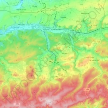
Warstein is located north of the Arnsberger Wald (forest) at a brook called Wäster. The area south of the city is mostly forested; the lightly forested Haarstrang mountain is to the north. The river Möhne flows between these two areas. The highest elevation is 581 m (1,906 ft) in the south of the city near a hill called Stimm Stamm; the lowest elevation is 216 m (709 ft) in the village Waldhausen in the north.
Sobre este mapa
Nome: Mapa topográfico Warstein, altitude, relevo.
Local: Warstein, Kreis Soest, North Rhine-Westphalia, 59581, Germany (51.38855 8.20178 51.52277 8.40984)
Altitude média: 373 m
Altitude mínima: 223 m
Altitude máxima: 582 m
Outros mapas topográficos
Clique em um mapa para visualizar sua topografia, sua altitude e seu relevo.