
Mapa topográfico Körbecke
Mapa interativo
Clique no mapa para exibir a altitude.
Sobre este mapa
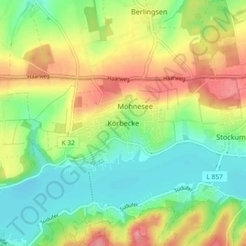
Nome: Mapa topográfico Körbecke, altitude, relevo.
Altitude média: 249 m
Altitude mínima: 208 m
Altitude máxima: 306 m
Outros mapas topográficos
Clique em um mapa para visualizar sua topografia, sua altitude e seu relevo.
Wickede (Ruhr)
Germany > North Rhine-Westphalia > Kreis Soest
Wickede (Ruhr), Kreis Soest, North Rhine-Westphalia, 58739, Germany
Altitude média: 177 m
Anröchte
Germany > North Rhine-Westphalia > Kreis Soest
Anröchte, Kreis Soest, North Rhine-Westphalia, 59609, Germany
Altitude média: 221 m
Parsit
Germany > North Rhine-Westphalia > Kreis Soest > Parsit
Parsit, Ense, Kreis Soest, North Rhine-Westphalia, 59469, Germany
Altitude média: 212 m
Lohne
Germany > North Rhine-Westphalia > Kreis Soest > Lohne
Lohne, Bad Sassendorf, Kreis Soest, North Rhine-Westphalia, 59505, Germany
Altitude média: 110 m
Kneblinghausen
Germany > North Rhine-Westphalia > Kreis Soest > Rüthen
Kneblinghausen, Rüthen, Kreis Soest, North Rhine-Westphalia, Germany
Altitude média: 367 m
Warstein
Germany > North Rhine-Westphalia > Kreis Soest
Warstein, Kreis Soest, North Rhine-Westphalia, 59581, Germany
Altitude média: 373 m
Lippstadt
Germany > North Rhine-Westphalia > Kreis Soest
Lippstadt, Kreis Soest, North Rhine-Westphalia, Germany
Altitude média: 94 m
Soest
Germany > North Rhine-Westphalia > Kreis Soest
Soest, Kreis Soest, North Rhine-Westphalia, 59494, Germany
Altitude média: 121 m
Werl
Germany > North Rhine-Westphalia > Kreis Soest
Werl, Kreis Soest, North Rhine-Westphalia, 59457, Germany
Altitude média: 122 m