
Mapa topográfico Sukma
Clique no mapa para exibir a altitude.
Sukma
This place can easily be a matter of research for the Archaeological department as there exists rare ancient sculptures in this area, one can see a sculpture on which Brahma, Vishnu and Mahesh the Trinity of Hindu faith can be seen on a single stone. Now with the elevation of this area into a new District people are hopeful that Archaeological department will start researching in this area and unveil the historical importance of the land to the outer world.
Sobre este mapa
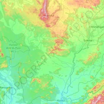
Nome: Mapa topográfico Sukma, altitude, relevo.
Local: Sukma, Chhattisgarh, India (17.78222 80.91126 18.77433 81.96794)
Altitude média: 256 m
Altitude mínima: 31 m
Altitude máxima: 1.340 m
Outros mapas topográficos
Clique em um mapa para visualizar sua topografia, sua altitude e seu relevo.
Kirandul
India > Chhattisgarh > Kuakonda Tahsil
The Kothavalasa–Kirandul line of East Coast Railway from Kirandul to Visakhapatnam via Koraput is laid through the Eastern Ghats. Up to Araku station, it has many tunnels. Also it pass through the highest elevation Broad gauge station in the Eastern ghats, Semiliguda, just before the Borra caves. Kirandul -…
Altitude média: 742 m
Raigarh
India > Chhattisgarh > Raigarh Tahsil
Raigarh is located at 21°54′N 83°24′E / 21.9°N 83.4°E / 21.9; 83.4. It has an average elevation of 215 metres (705 feet). The Kelo river flows through the city, which is one of its main water sources.
Altitude média: 216 m
Balodabazar
India > Chhattisgarh > Baloda Bazar Tahsil
Baloda Bazar is located at 30°40′N 82°10′E / 30.67°N 82.17°E / 30.67; 82.17. It has an average elevation of 254 m (833 ft). There are several tourist places in Balodabazaar like Sirpur, Turturia, Giroudpuri, Siddheswr Mandir Pallari and many more.
Altitude média: 251 m
veterinary hospital vilvattom
India > Chhattisgarh > Jaijaipur Tahsil > Bawanbadi
Altitude média: 236 m
Rajim
India > Chhattisgarh > Rajim Tahsil
It is located at an elevation of 281 m above MSL.
Altitude média: 286 m
Kawardha
India > Chhattisgarh > Kawardha Tahsil
Kawardha is located at 22°01′N 81°15′E / 22.02°N 81.25°E / 22.02; 81.25. The total area is 798 square miles (2,070 km2). The state consists of hills and forests. It has an average elevation of 353 metres (1,158 ft).
Altitude média: 350 m
Sukma
India > Chhattisgarh > Sukma Tahsil
It is located at 18°24′0″N 81°40′0″E / 18.40000°N 81.66667°E / 18.40000; 81.66667 at an elevation of 210 m above MSL.
Altitude média: 219 m
Pendra
India > Chhattisgarh > Pendra Tahsil
Pendra has an average elevation of 617 metres (2,024 ft).
Altitude média: 594 m