
Obrigado por apoiar este site ❤️
Faça uma doação
Faça uma doação
Mapa topográfico Kirandul
Clique no mapa para exibir a altitude.
Obrigado por apoiar este site ❤️
Faça uma doação
Faça uma doação
Kirandul
The Kothavalasa–Kirandul line of East Coast Railway from Kirandul to Visakhapatnam via Koraput is laid through the Eastern Ghats. Up to Araku station, it has many tunnels. Also it pass through the highest elevation Broad gauge station in the Eastern ghats, Semiliguda, just before the Borra caves. Kirandul - Kottavalasa Railroad is the record high Broad Gauge line in the Eastern Ghats. The KK Line has the distinction of being the second highest broad gauge railway line in the country after the one in Jammu.
Obrigado por apoiar este site ❤️
Faça uma doação
Faça uma doação
Sobre este mapa
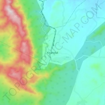
Nome: Mapa topográfico Kirandul, altitude, relevo.
Altitude média: 742 m
Altitude mínima: 541 m
Altitude máxima: 1.270 m
Obrigado por apoiar este site ❤️
Faça uma doação
Faça uma doação