
Faça uma doação
Mapa topográfico Bakewell CP
Clique no mapa para exibir a altitude.
Faça uma doação
Bakewell CP
The Manchester, Buxton, Matlock and Midlands Junction Railway opened Bakewell railway station in 1862, then became part of the Midland Railway and later of the LMS main line from London to Manchester. John Ruskin objected to what he saw as desecration of the Derbyshire countryside and to the fact that "every fool in Buxton can be at Bakewell in half an hour, and every fool in Bakewell at Buxton." In return for the Duke of Rutland's permission for the line to pass through his estate at Haddon Hall, Bakewell station buildings on the hillside overlooking the town are more imposing than expected and the Duke's coat of arms is carved in the stonework. Such pandering to landowners was common at the time, as their support was needed to pass the Act of Parliament allowing the line to be built. However, the inconvenient altitude of the line forced Bakewell station to be placed out of town, as the Duke insisted it be out of sight of Haddon Hall. These buildings are now used by small businesses, as the line between Matlock and Buxton was closed in 1968. Most of it has been designated the Monsal Trail, a bridle path for walking, cycling and riding.
Faça uma doação
Sobre este mapa
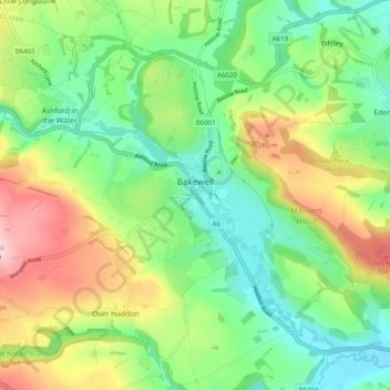
Nome: Mapa topográfico Bakewell CP, altitude, relevo.
Altitude média: 194 m
Altitude mínima: 103 m
Altitude máxima: 353 m
Faça uma doação
Outros mapas topográficos
Clique em um mapa para visualizar sua topografia, sua altitude e seu relevo.