
Obrigado por apoiar este site ❤️
Faça uma doação
Faça uma doação
Mapa topográfico Matlock
Clique no mapa para exibir a altitude.
Obrigado por apoiar este site ❤️
Faça uma doação
Faça uma doação
Sobre este mapa
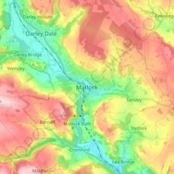
Nome: Mapa topográfico Matlock, altitude, relevo.
Altitude média: 213 m
Altitude mínima: 76 m
Altitude máxima: 367 m
Obrigado por apoiar este site ❤️
Faça uma doação
Faça uma doação
Outros mapas topográficos
Clique em um mapa para visualizar sua topografia, sua altitude e seu relevo.
Bakewell CP
United Kingdom > England > Derbyshire > Derbyshire Dales
The Manchester, Buxton, Matlock and Midlands Junction Railway opened Bakewell railway station in 1862, then became part of the Midland Railway and later of the LMS main line from London to Manchester. John Ruskin objected to what he saw as desecration of the Derbyshire countryside and to the fact that "every…
Altitude média: 194 m