
Obrigado por apoiar este site ❤️
Faça uma doação
Faça uma doação
Mapa topográfico Orsay
Clique no mapa para exibir a altitude.
Obrigado por apoiar este site ❤️
Faça uma doação
Faça uma doação
Sobre este mapa
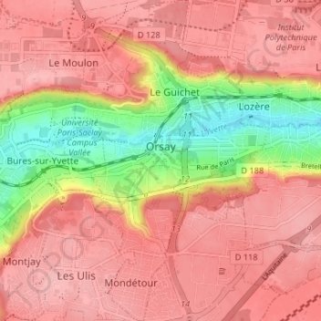
Nome: Mapa topográfico Orsay, altitude, relevo.
Altitude média: 131 m
Altitude mínima: 53 m
Altitude máxima: 168 m
Obrigado por apoiar este site ❤️
Faça uma doação
Faça uma doação
Outros mapas topográficos
Clique em um mapa para visualizar sua topografia, sua altitude e seu relevo.
Paris Basin
France > Ile-de-France > Essonne > Bièvres
The landscape is one of very broad valleys (flood plains), modest watershed hills and well-drained plateaux of comparatively little altitude. In the south-east and east the plain of Champagne and the Seuil de Bourgogne (Threshold of Burgundy) differential erosion of the strata has left low scarps with the dip…
Altitude média: 126 m