
Faça uma doação
Mapa topográfico Panguitch Lake
Clique no mapa para exibir a altitude.
Faça uma doação
Sobre este mapa
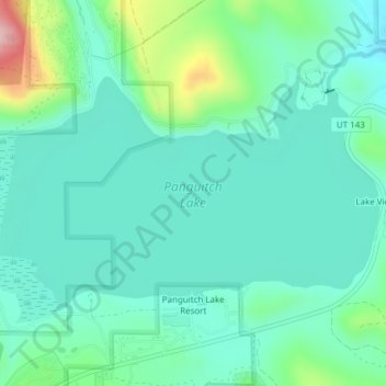
Nome: Mapa topográfico Panguitch Lake, altitude, relevo.
Local: Panguitch Lake, Garfield County, Utah, United States (37.70752 -112.66119 37.72596 -112.62316)
Altitude média: 2.528 m
Altitude mínima: 2.476 m
Altitude máxima: 2.707 m
Faça uma doação
Outros mapas topográficos
Clique em um mapa para visualizar sua topografia, sua altitude e seu relevo.
Bryce Canyon National Park
United States > Utah > Garfield County
Bryce Canyon National Park (/braɪs/) is an American national park located in southwestern Utah. The major feature of the park is Bryce Canyon, which despite its name, is not a canyon, but a collection of giant natural amphitheaters along the eastern side of the Paunsaugunt Plateau. Bryce is distinctive due to…
Altitude média: 2.259 m
Mount Ellen
United States > Utah > Garfield County
Mount Ellen is an ultra prominent peak, meaning that it has more than 1,500 metres (4,921 ft) of topographic prominence, standing out considerably from nearby mountains. It stands in the watershed of the Fremont River, which together with Muddy Creek forms the Dirty Devil River, which drains into the Colorado…
Altitude média: 3.149 m
Faça uma doação
Escalante Petrified Forest State Park
United States > Utah > Garfield County > Escalante
Altitude média: 1.832 m
Faça uma doação
Bryce Canyon National Park
United States > Utah > Garfield County
Bryce Canyon National Park (/braɪs/) is an American national park located in southwestern Utah. The major feature of the park is Bryce Canyon, which despite its name, is not a canyon, but a collection of giant natural amphitheaters along the eastern side of the Paunsaugunt Plateau. Bryce is distinctive due to…
Altitude média: 2.259 m
Faça uma doação
Panguitch
United States > Utah > Garfield County
Panguitch has a cool semi-arid climate (Köppen BSk) with summers featuring hot afternoons and cold mornings, and cold, dry winters. The high altitude and relatively high latitude means that mornings are cold throughout the year and freezing for most of it: between 1971 and 2000 an average of 227.7 mornings…
Altitude média: 2.043 m
Faça uma doação