
Mapa topográfico Bryce Canyon National Park
Mapa interativo
Clique no mapa para exibir a altitude.
Sobre este mapa
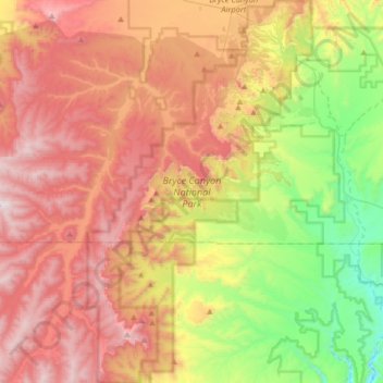
Nome: Mapa topográfico Bryce Canyon National Park, altitude, relevo.
Altitude média: 2.259 m
Altitude mínima: 1.640 m
Altitude máxima: 2.902 m
Bryce Canyon National Park (/braɪs/) is an American national park located in southwestern Utah. The major feature of the park is Bryce Canyon, which despite its name, is not a canyon, but a collection of giant natural amphitheaters along the eastern side of the Paunsaugunt Plateau. Bryce is distinctive due to geological structures called hoodoos, formed by frost weathering and stream erosion of the river and lake bed sedimentary rocks. The red, orange, and white colors of the rocks provide spectacular views for park visitors. Bryce Canyon National Park is much smaller and sits at a much higher elevation than nearby Zion National Park. The rim at Bryce varies from 8,000 to 9,000 feet (2,400 to 2,700 m).
Outros mapas topográficos
Clique em um mapa para visualizar sua topografia, sua altitude e seu relevo.
Capitol Reef National Park
United States > Utah > Garfield County
Capitol Reef National Park, Garfield County, Utah, United States
Altitude média: 1.963 m
Boulder
United States > Utah > Garfield County
Boulder, Garfield County, Utah, 84716, United States
Altitude média: 2.115 m
Panguitch
United States > Utah > Garfield County
Panguitch, Garfield County, Utah, 84759, United States
Altitude média: 2.043 m
Mount Ogden
United States > Utah > Garfield County
Mount Ogden, Garfield County, Utah, United States
Altitude média: 2.226 m
Escalante
United States > Utah > Garfield County
Escalante, Garfield County, Utah, 84726, United States
Altitude média: 1.781 m
Henry Mountains
United States > Utah > Garfield County
Henry Mountains, Garfield County, Utah, United States
Altitude média: 1.936 m
Bryce Canyon
United States > Utah > Garfield County > Tropic
Bryce Canyon, Tropic, Garfield County, Utah, United States
Altitude média: 2.247 m