
Mapa topográfico Elstree
Clique no mapa para exibir a altitude.
Elstree
In 1723, topographer John Norden noted in his book Speculum Britanniae, that in the county of Hartfordshire [sic] was one "Elstre or Eglestre". In an earlier edition, he writes.
Sobre este mapa
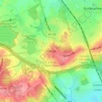
Nome: Mapa topográfico Elstree, altitude, relevo.
Altitude média: 105 m
Altitude mínima: 64 m
Altitude máxima: 152 m
Outros mapas topográficos
Clique em um mapa para visualizar sua topografia, sua altitude e seu relevo.