
Mapa topográfico Aldenham
Clique no mapa para exibir a altitude.
Sobre este mapa
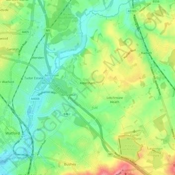
Nome: Mapa topográfico Aldenham, altitude, relevo.
Altitude média: 82 m
Altitude mínima: 52 m
Altitude máxima: 136 m
Outros mapas topográficos
Clique em um mapa para visualizar sua topografia, sua altitude e seu relevo.
Elstree
United Kingdom > England > Hertfordshire > Hertsmere
In 1723, topographer John Norden noted in his book Speculum Britanniae, that in the county of Hartfordshire [sic] was one "Elstre or Eglestre". In an earlier edition, he writes.
Altitude média: 105 m
Bushey
United Kingdom > England > Hertfordshire > Hertsmere
Bushey is a town in the Hertsmere borough of Hertfordshire in the East of England. It had a population of 25,328 in the 2011 census, rising to 28,416 in the 2021 census, an increase of 12.19%. This makes Bushey the second most populated town in Hertsmere. Bushey Heath is a large neighbourhood south east of…
Altitude média: 88 m
Bentley Heath
United Kingdom > England > Hertfordshire > Hertsmere > Potters Bar
Altitude média: 105 m
Well End
United Kingdom > England > Hertfordshire > Hertsmere > Borehamwood > Shenley
Altitude média: 108 m
Merry Hill
United Kingdom > England > Hertfordshire > Hertsmere > Bushey Heath > Merry Hill
Altitude média: 98 m
Bushey
United Kingdom > England > Hertfordshire > Hertsmere
Bushey is a town in the Hertsmere borough of Hertfordshire in the East of England. It had a population of 25,328 in the 2011 census, rising to 28,416 in the 2021 census, an increase of 12.19%. This makes Bushey the second most populated town in Hertsmere. Bushey Heath is a large neighbourhood south east of…
Altitude média: 88 m
Elstree
United Kingdom > England > Hertfordshire > Hertsmere
In 1723, topographer John Norden noted in his book Speculum Britanniae, that in the county of Hartfordshire [sic] was one "Elstre or Eglestre". In an earlier edition, he writes.
Altitude média: 105 m