
Faça uma doação
Mapa topográfico Broomfield
Clique no mapa para exibir a altitude.
Faça uma doação
Broomfield
The elevation in Broomfield ranges from 5,096 to 5,856 feet. At the 2020 United States Census, Broomfield had a total area of 21,471 acres (86.890 km2) including 371 acres (1.503 km2) of water. It is the smallest county by area in Colorado and the 5th smallest in the United States. Broomfield is the second most densely populated county in Colorado behind Denver.
Faça uma doação
Sobre este mapa
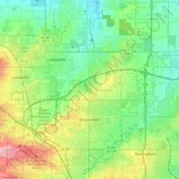
Nome: Mapa topográfico Broomfield, altitude, relevo.
Local: Broomfield, Colorado, United States (39.88920 -105.16726 40.04423 -104.96093)
Altitude média: 1.609 m
Altitude mínima: 1.532 m
Altitude máxima: 1.777 m
Faça uma doação
Outros mapas topográficos
Clique em um mapa para visualizar sua topografia, sua altitude e seu relevo.
Evergreen
United States > Colorado > Jefferson County
Evergreen sits at an elevation of 7,220 feet (2,200 m) in the Rocky Mountains, 19 miles west of Denver, Colorado. Its addresses are oriented according to the Street_system_of_Denver.
Altitude média: 2.309 m
Lakewood
United States > Colorado > Jefferson County > Lakewood
Lakewood is located at 39°42′17″N 105°04′53″W / 39.70472°N 105.08139°W / 39.70472; -105.08139 at an elevation of 5,518 feet (1,682 m). Located at the junction of U.S. Route 6 and Colorado State Highway 121 in central Colorado, the city lies immediately west of Denver and 62 miles (100 km)…
Altitude média: 1.717 m
Faça uma doação
Faça uma doação
Faça uma doação
Faça uma doação
Humboldt Peak
United States > Colorado > Custer County
According to the Köppen climate classification system, Humboldt is located in an alpine subarctic climate zone with cold, snowy winters, and cool to warm summers. Due to its altitude, it receives precipitation all year, as snow in winter, and as thunderstorms in summer, with a dry period in late spring.
Altitude média: 3.738 m
Faça uma doação
Castle Peak
United States > Colorado > Pitkin County
There are two other peaks in Colorado that have the same name: one in Eagle County at 39°46′23″N 106°50′04″W / 39.7730422°N 106.8344844°W / 39.7730422; -106.8344844, with an elevation 11,280+ feet, (3438+ m); and the other in Mesa County at 39°16′16″N 108°05′40″W /…
Altitude média: 3.909 m
Torreys Peak
United States > Colorado > Clear Creek County
The third trail starts at Loveland Pass about 4.5 miles (7.2 km) to the northwest. To reach Loveland Pass, follow I-70 west from Denver 55 miles (89 km) to where US Route 6 breaks off and heads south. Follow the meandering Route 6 approximately seven miles to the trailhead at Loveland Pass, at an elevation of…
Altitude média: 3.854 m
Quandary Peak
United States > Colorado > Summit County
Quandary Peak is the highest summit of the Tenmile Range in the Rocky Mountains of North America at 14,271 ft (4,350 m). As of 2018, it was the most commonly climbed fourteener in Colorado. It has nearly the same elevation as Castle Peak and Mount Blue Sky. It lies in Summit County and within the White River…
Altitude média: 3.833 m
Faça uma doação
Faça uma doação
Mount Harvard
United States > Colorado > Chaffee County
In 1962, three Harvard men attempted to erect a fourteen-foot metal pole on the top of Harvard, with a sign that read "Mt. Harvard, 14,434. This sign erected at an altitude of 14,434 making it the second highest point in the contiguous United States." Before they could reach the top of the mountain darkness…
Altitude média: 3.936 m
Faça uma doação
Grand Lake
United States > Colorado > Grand County
Established in 1881, Grand Lake sits at an elevation of 8,369 feet (2,551 m) and derives its name from the lake on whose shores it is situated: Grand Lake, the largest natural body of water in Colorado. The town of Grand Lake was originally an outfitting and supply point for the mining settlements of Lulu…
Altitude média: 2.630 m
Pikes Peak
United States > Colorado > El Paso County
Pikes Peak or America's Mountain is an ultra-prominent fourteener of the Front Range of the Rocky Mountains of North America. Pikes Peak's summit has an elevation of 14,115 ft (4,302 m) above sea level. Pikes Peak is in Pike National Forest, Colorado, with the base located in the town of Manitou Springs, 10…
Altitude média: 3.902 m
Faça uma doação
Argentine Pass
United States > Colorado > Summit County
Argentine Pass, elevation 13,207 ft (4,025 m), is a high mountain pass that crosses the Continental Divide in the Front Range of the Rocky Mountains of central Colorado in the United States. Argentine Pass is located on the crest of the Front Range along the boundary southwest of Georgetown and is the highest…
Altitude média: 3.797 m
Rogers Pass
United States > Colorado > Gilpin County
Rogers Pass, elevation 11,866 ft (3,617 m), is a mountain pass in the Front Range of central Colorado. The pass crosses the continental divide in the James Peak Wilderness.
Altitude média: 3.448 m
Faça uma doação
Faça uma doação
Vail
United States > Colorado > Eagle County
Vail's average elevation is 8,150 feet (2484 m) above sea level. The town has a total area of 4.5 square miles (12 km2), with no lakes (there is, however, at least one pond). Gore Creek flows from east to west through the center of town.
Altitude média: 2.953 m
Fairplay
United States > Colorado > Park County
The historic Town of Fairplay is the Statutory Town that is the county seat and the most populous municipality of Park County, Colorado, United States. The town population was 724 at the 2020 United States Census. Fairplay is located in South Park at an elevation of 9,953 feet (3,034 m). The town is the…
Altitude média: 3.045 m
Estes Park
United States > Colorado > Larimer County
Estes Park sits at an elevation of 7,522 feet (2,293 m) on the front range of the Rocky Mountains at the eastern entrance of the Rocky Mountain National Park. Its north, south and east extremities border the Roosevelt National Forest. Lumpy Ridge lies immediately north of Estes Park.
Altitude média: 2.543 m
Faça uma doação
Faça uma doação
Faça uma doação
Faça uma doação
Faça uma doação
Faça uma doação
Crested Butte
United States > Colorado > Gunnison County
Crested Butte is located in north-central Gunnison County on the west side of the valley of the Slate River, along Coal Creek. Colorado State Highway 135 runs south from Crested Butte 27 miles (43 km) to Gunnison, the county seat. According to the United States Census Bureau, the town of Crested Butte has a…
Altitude média: 2.798 m
Faça uma doação
Faça uma doação
Alamo Square Park
United States > Colorado > El Paso County > Colorado Springs
Altitude média: 1.831 m
Faça uma doação
Faça uma doação
Faça uma doação
South Boulder Canyon Ditch
United States > Colorado > Boulder County > Lafayette
Altitude média: 1.618 m
Faça uma doação
Faça uma doação
Loveland Pass
United States > Colorado > Clear Creek County
Loveland Pass is a high mountain pass in north-central Colorado, at an elevation of 11,990 feet (3,655 m) above sea level in the Rocky Mountains of the Western United States.
Altitude média: 3.639 m
Mount Blue Sky
United States > Colorado > Clear Creek County
The history of the Mount Blue Sky Scenic Byway is part of a larger story of the Denver Mountain Parks system. The City and County of Denver initiated the construction of a series of automobile "scenic loops" to allow Denverites to explore the mountains. One road circuit, Circle G, was to traverse the ridge to…
Altitude média: 4.006 m
Faça uma doação