
Obrigado por apoiar este site ❤️
Faça uma doação
Faça uma doação
Mapa topográfico Poage Lake
Clique no mapa para exibir a altitude.
Obrigado por apoiar este site ❤️
Faça uma doação
Faça uma doação
Sobre este mapa
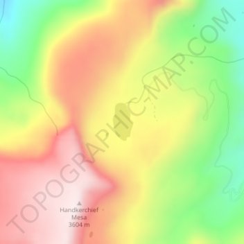
Nome: Mapa topográfico Poage Lake, altitude, relevo.
Local: Poage Lake, Rio Grande County, Colorado, United States (37.49747 -106.64449 37.50166 -106.64166)
Altitude média: 3.369 m
Altitude mínima: 3.094 m
Altitude máxima: 3.607 m
Obrigado por apoiar este site ❤️
Faça uma doação
Faça uma doação
Outros mapas topográficos
Clique em um mapa para visualizar sua topografia, sua altitude e seu relevo.
Del Norte
United States > Colorado > Rio Grande County
Relatively-speaking, it is located where the Rio Grande leaves the San Juan Mountains and enters the San Luis Valley, near its confluences with Pinos Creek and San Francisco Creek, respectively. Due to its location on the western edge of the valley, a variety of climates, vegetation regions, and ecosystems…
Altitude média: 2.416 m
Obrigado por apoiar este site ❤️
Faça uma doação
Faça uma doação