
Faça uma doação
Mapa topográfico Somerset
Clique no mapa para exibir a altitude.
Faça uma doação
Somerset
Many settlements developed because of their strategic importance in relation to geographical features, such as river crossings or valleys in ranges of hills. Examples include Axbridge on the River Axe, Castle Cary on the River Cary, North Petherton on the River Parrett, and Ilminster, where there was a crossing point on the River Isle. Midsomer Norton lies on the River Somer; while the Wellow Brook and the Fosse Way Roman road run through Radstock. Chard is the most southerly town in Somerset and one of the highest, though at an altitude of 126 m (413 ft) Wiveliscombe is the highest town in the county.
Faça uma doação
Sobre este mapa
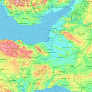
Nome: Mapa topográfico Somerset, altitude, relevo.
Local: Somerset, England, United Kingdom (50.82084 -3.83980 51.50269 -2.24440)
Altitude média: 96 m
Altitude mínima: -4 m
Altitude máxima: 562 m
Faça uma doação
Outros mapas topográficos
Clique em um mapa para visualizar sua topografia, sua altitude e seu relevo.
Cambridge
United Kingdom > England > Cambridge
The city, like most of the UK, has a maritime climate highly influenced by the Gulf Stream. Located in the driest region of Britain, Cambridge's rainfall averages around 570 mm (22.44 in) per year, around half the national average, with some years occasionally falling into the semi-arid (under 500 mm (19.69…
Altitude média: 18 m
Faça uma doação
Leeds
Lying in the eastern foothills of the Pennines, there is a significant variation in elevation within the city's built-up area. The district ranges from 1,115 feet (340 m) in the far west on the slopes of Ilkley Moor to about 33 feet (10 m) where the rivers Aire and Wharfe cross the eastern boundary. Land rises…
Altitude média: 94 m
Swindon
United Kingdom > England > Swindon
Swindon has an oceanic climate (Cfb in the Köppen climate classification), like the vast majority of the British Isles, with cool winters and warm summers. The nearest official weather station is RAF Lyneham, about 10 miles (16 km) west southwest of Swindon town centre. The weather station's elevation is 145…
Altitude média: 108 m
Faça uma doação
Plymouth
United Kingdom > England > Devon > Plymouth
The River Plym, which flows off Dartmoor to the north-east, forms a smaller estuary to the east of the city called Cattewater. Plymouth Sound is protected from the sea by the Plymouth Breakwater, in use since 1814. In the Sound is Drake's Island which is seen from Plymouth Hoe, a flat public area on top of…
Altitude média: 81 m
Faça uma doação
Faça uma doação
Reading
United Kingdom > England > Reading
Mary Russell Mitford lived in Reading for a number of years and then spent the rest of her life just outside the town at Three Mile Cross and Swallowfield. The fictional Belford Regis of her eponymous novel, first published in 1835, is largely based on Reading. Described with topographical accuracy, it is…
Altitude média: 56 m
Faça uma doação
Faça uma doação
Bathwick Hill
United Kingdom > England > Bath and North East Somerset > Bath
Number 1 (Bathwick Lodge) is a 2-storey villa with a steep Mansard room, built in 1825, extended in 1840 and the late C19. Probably by John Pinch the Elder.[4] Number 2 is from the early 19th century and has shutters over the windows.[11] Number 3 includes a porch which is elaborately enriched with carving,…
Altitude média: 93 m
Faça uma doação
Faça uma doação
Faça uma doação
Portsmouth
United Kingdom > England > Hampshire > Portsmouth
By road, Portsmouth lies 73.5 miles (118.3 km) from Central London, 49.5 miles (79.7 km) west of Brighton, and 22.3 miles (35.9 km) east of Southampton. Portsmouth is situated primarily on Portsea Island and is the United Kingdom's only island city, although parts of it have expanded onto the mainland. Gosport…
Altitude média: 28 m
Faça uma doação
St Albans
United Kingdom > England > Hertfordshire > St Albans
St Albans was an ancient borough created following the dissolution of the monastery in 1539. It consisted of the ancient parish of St Albans (also known as the Abbey parish) and parts of St Michael and St Peter. The municipal corporation was reformed by the Municipal Corporations Act 1835 and the boundary was…
Altitude média: 100 m
Croydon
United Kingdom > England > Greater London
Several apartment developments, for instance Altitude 25 (completed 2010), have been built in recent years, and several more are being built or planned. The construction of Saffron Square, which includes a 43-storey tower, began on Wellesley Road in 2011 and was completed in 2016. Other developments with…
Altitude média: 70 m
Faça uma doação
Peterborough
United Kingdom > England > Cambridgeshire
The local topography is flat, and in some places, the land lies below sea level, for example in parts of the Fens to the east and to the south of Peterborough. Human settlement in the area began before the Bronze Age, as can be seen at the Flag Fen archaeological site to the east of the current city centre,…
Altitude média: 17 m
Hay Stacks
United Kingdom > England > Cumberland
Haystacks, or Hay Stacks, is a hill in England's Lake District, situated at the south-eastern end of the Buttermere Valley. Although not of any great elevation (597 m, 1,958 ft), Haystacks has become one of the most popular fells in the area. This fame is partly due to the writings of Alfred Wainwright, who…
Altitude média: 386 m
Faça uma doação
Faça uma doação
Reigate
United Kingdom > England > Surrey > Reigate and Banstead
Reigate is in central Surrey, around 19 mi (30 km) south of central London and 9 mi (14 km) north of Gatwick Airport. The town is in the Vale of Holmesdale, below the North Downs escarpment. The average elevation in the centre is 80 m (260 ft) above ordnance datum (OD) and the area is drained by the Wallace…
Altitude média: 100 m
Faça uma doação
Bedford
United Kingdom > England > Bedford
As with the rest of the United Kingdom, Bedford has a maritime climate, with a limited range of temperatures, and generally even rainfall throughout the year. The nearest Met Office weather station to Bedford is Bedford (Thurleigh) airport, about 6.5 miles (10.5 km) north of Bedford town centre at an elevation…
Altitude média: 37 m
Faça uma doação
Faça uma doação
Hergest Ridge
United Kingdom > England > Herefordshire
Hergest Ridge is a large elongated hill which traverses the border between England and Wales in the United Kingdom, between the town of Kington in Herefordshire and the village of Gladestry in Powys. Its highest point, which is in England, is 426 metres (1,398 ft) high. It has a topographic prominence of 157.6…
Altitude média: 308 m
Faça uma doação
Faça uma doação
Faça uma doação
Harrogate
United Kingdom > England > North Yorkshire
Harrogate is situated on the edge of the Yorkshire Dales, with the Vale of York to the east and the upland Yorkshire Dales to the west and north-west. It has a dry and mild climate, typical of places in the rain shadow of the Pennines. It is on the A59 from Skipton to York. At an altitude of between 100 and…
Altitude média: 106 m
South Moor
United Kingdom > England > County Durham > Stanley > Quaking Houses > South Moor
Altitude média: 202 m
Cambridge
United Kingdom > England > Cambridgeshire
The city, like most of the UK, has a maritime climate highly influenced by the Gulf Stream. Located in the driest region of Britain, Cambridge's rainfall averages around 570 mm (22.44 in) per year, around half the national average, The driest recent year was in 2011 with 380.4 mm (14.98 in) of rain at the…
Altitude média: 33 m
Faça uma doação
Winter Hill
United Kingdom > England > Blackburn with Darwen > Tockholes
Paths to the summit lead from Belmont (in Blackburn with Darwen), Rivington (in Chorley borough), and Horwich and Blackrod (in Bolton borough). The summit can also be reached via a short walk from the top of a road pass 1+1⁄4 miles (2 km) west of Belmont. The hill is a prominent feature on the skyline for…
Altitude média: 205 m
Malvern
United Kingdom > England > Worcestershire > Malvern Hills
Malvern lies in the Lower Severn/Avon plain affording it a degree of shelter caused by virtue of its nestling in between the Cotswold hills to the east, the Welsh Hills and Mountains to the west, and Birmingham plateau to the north. Although as with all the British Isles it has a maritime climate, the local…
Altitude média: 95 m
Faça uma doação
Faça uma doação
Haslingden Grane
United Kingdom > England > Lancashire > Borough of Rossendale > Haslingden
Altitude média: 287 m
Scafell Pike
United Kingdom > England > Cumberland
Scafell Pike (/ˈskɔːfɛl paɪk/) is the highest and the most prominent mountain in England, at an elevation of 978 metres (3,209 ft) above sea level. It is located in the Lake District National Park, in Cumbria, and is part of the Southern Fells and the Scafell massif.
Altitude média: 679 m
Faça uma doação
Faça uma doação
Faça uma doação