
Mapa topográfico Hebden Bridge
Clique no mapa para exibir a altitude.
Sobre este mapa
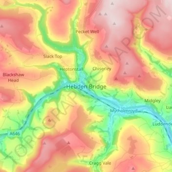
Nome: Mapa topográfico Hebden Bridge, altitude, relevo.
Altitude média: 277 m
Altitude mínima: 85 m
Altitude máxima: 447 m
Outros mapas topográficos
Clique em um mapa para visualizar sua topografia, sua altitude e seu relevo.
Todmorden
United Kingdom > England > Calderdale > Lydgate
Todmorden Town Hall, which was designed in the Neo-Classical style, dominates the centre of the town. The building straddles the Walsden Water, a tributary of the River Calder, and was situated in both Lancashire and Yorkshire until the administrative county boundary was moved on 1 January 1888. Designed by…
Altitude média: 311 m
Calder & Hebble Navigation Halifax Cut
United Kingdom > England > Calderdale > Skircoat Green
Altitude média: 136 m
Ragby Plantation
United Kingdom > England > Calderdale > Todmorden > Walsden > Bottoms
Altitude média: 293 m
Gaddings Dam
United Kingdom > England > Calderdale > Todmorden > Walsden
Gaddings Dam is a locally owned reservoir near to Todmorden in West Yorkshire, England. The dam was built to power water mills in the Todmorden area, being superseded by steam power and left redundant. It is notable for having a sandy beach at the north-eastern side which attracts people to it during the…
Altitude média: 283 m
Todmorden
United Kingdom > England > Calderdale
Todmorden Town Hall, which was designed in the Neo-Classical style, dominates the centre of the town. The building straddles the Walsden Water, a tributary of the River Calder, and was situated in both Lancashire and Yorkshire until the administrative county boundary was moved on 1 January 1888. Designed by…
Altitude média: 311 m