
Mapa topográfico Erkrath
Mapa interativo
Clique no mapa para exibir a altitude.
Sobre este mapa
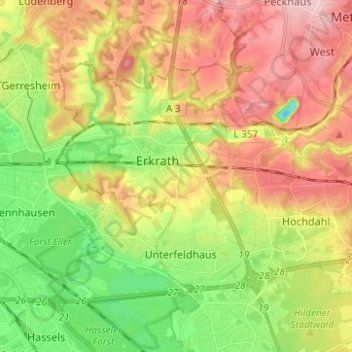
Nome: Mapa topográfico Erkrath, altitude, relevo.
Local: Erkrath, Kreis Mettmann, North Rhine-Westphalia, Germany (51.19275 6.87107 51.24253 6.99518)
Altitude média: 81 m
Altitude mínima: -12 m
Altitude máxima: 176 m
Outros mapas topográficos
Clique em um mapa para visualizar sua topografia, sua altitude e seu relevo.
Abtsküche / Haus Hetterscheidt
Germany > North Rhine-Westphalia > Kreis Mettmann > Heiligenhaus > Tüschen
Abtsküche / Haus Hetterscheidt, Tüschen, Heiligenhaus, Kreis Mettmann, North Rhine-Westphalia, 42579, Germany
Altitude média: 168 m
Wülfrath
Germany > North Rhine-Westphalia > Kreis Mettmann
Wülfrath, Kreis Mettmann, North Rhine-Westphalia, 42489, Germany
Altitude média: 187 m
Langenfeld (Rheinland)
Germany > North Rhine-Westphalia > Kreis Mettmann
Langenfeld (Rheinland), Kreis Mettmann, North Rhine-Westphalia, 40764, Germany
Altitude média: 55 m
Haan
Germany > North Rhine-Westphalia > Kreis Mettmann > Haan
Haan, Kreis Mettmann, North Rhine-Westphalia, 42781, Germany
Altitude média: 149 m
Hilden
Germany > North Rhine-Westphalia > Kreis Mettmann
Hilden, Kreis Mettmann, North Rhine-Westphalia, Germany
Altitude média: 55 m
Ratingen
Germany > North Rhine-Westphalia > Kreis Mettmann
Ratingen, Kreis Mettmann, North Rhine-Westphalia, Germany
Altitude média: 71 m
Velbert
Germany > North Rhine-Westphalia > Kreis Mettmann
Velbert, Kreis Mettmann, North Rhine-Westphalia, Germany
Altitude média: 172 m
Mettmann
Germany > North Rhine-Westphalia > Kreis Mettmann
Mettmann, Kreis Mettmann, North Rhine-Westphalia, 40822, Germany
Altitude média: 149 m