
Mapa topográfico Velbert
Mapa interativo
Clique no mapa para exibir a altitude.
Velbert
Velbert stands on the highest part of the Niederberg region and also in its centre. Its average elevation is around 230 metres above sea level; its highest point, at 303 metres, is the Hordt-Berg, and its lowest, at around 70.6 metres, is in Nierenhof am Deilbach. The highest point in Velbert itself is 263 metres above sea level, at the corner of Friedrichstraße and Langenberger Straße.
Sobre este mapa
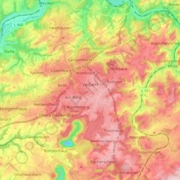
Nome: Mapa topográfico Velbert, altitude, relevo.
Local: Velbert, Kreis Mettmann, North Rhine-Westphalia, Germany (51.29318 7.00131 51.38142 7.16978)
Altitude média: 172 m
Altitude mínima: 21 m
Altitude máxima: 292 m
Outros mapas topográficos
Clique em um mapa para visualizar sua topografia, sua altitude e seu relevo.
Abtsküche / Haus Hetterscheidt
Germany > North Rhine-Westphalia > Kreis Mettmann > Heiligenhaus > Tüschen
Altitude média: 168 m