
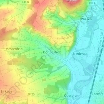
Mapa topográfico Döringstadt
Mapa interativo
Clique no mapa para exibir a altitude.
Sobre este mapa
Nome: Mapa topográfico Döringstadt, altitude, relevo.
Altitude média: 299 m
Altitude mínima: 244 m
Altitude máxima: 400 m
Outros mapas topográficos
Clique em um mapa para visualizar sua topografia, sua altitude e seu relevo.
Schwabthal
Deutschland > Bayern > Landkreis Lichtenfels > Bad Staffelstein
Schwabthal, Bad Staffelstein, Landkreis Lichtenfels, Bayern, Deutschland
Altitude média: 432 m
Schwürbitz
Deutschland > Bayern > Landkreis Lichtenfels
Schwürbitz, Michelau i.OFr., Landkreis Lichtenfels, Bayern, 96275, Deutschland
Altitude média: 292 m
Lichtenfels
Deutschland > Bayern > Landkreis Lichtenfels
Lichtenfels, Landkreis Lichtenfels, Bayern, 96215, Deutschland
Altitude média: 348 m