
Mapa topográfico Schwürbitz
Mapa interativo
Clique no mapa para exibir a altitude.
Sobre este mapa
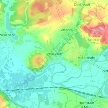
Nome: Mapa topográfico Schwürbitz, altitude, relevo.
Altitude média: 292 m
Altitude mínima: 259 m
Altitude máxima: 367 m
Schwürbitz liegt am Main, auf einer Höhe von 287 m ü. NHN und hat 1446 Einwohner (Stand: 30. Juni 2017). Es liegt am nördlichsten Punkt des Mains.
Outros mapas topográficos
Clique em um mapa para visualizar sua topografia, sua altitude e seu relevo.
Schwabthal
Deutschland > Bayern > Landkreis Lichtenfels > Bad Staffelstein
Schwabthal, Bad Staffelstein, Landkreis Lichtenfels, Bayern, Deutschland
Altitude média: 432 m
Döringstadt
Deutschland > Bayern > Landkreis Lichtenfels
Döringstadt, Ebensfeld, Landkreis Lichtenfels, Bayern, 96250, Deutschland
Altitude média: 299 m
Lichtenfels
Deutschland > Bayern > Landkreis Lichtenfels
Lichtenfels, Landkreis Lichtenfels, Bayern, 96215, Deutschland
Altitude média: 348 m