
Faça uma doação
Mapa topográfico Bezirk Bludenz
Clique no mapa para exibir a altitude.
Faça uma doação
Sobre este mapa
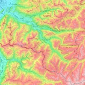
Nome: Mapa topográfico Bezirk Bludenz, altitude, relevo.
Local: Bezirk Bludenz, Vorarlberg, Austria (46.84086 9.60705 47.29470 10.22204)
Altitude média: 1.640 m
Altitude mínima: 424 m
Altitude máxima: 3.294 m
Faça uma doação
Outros mapas topográficos
Clique em um mapa para visualizar sua topografia, sua altitude e seu relevo.
Faça uma doação
Zürs
Austria > Vorarlberg > Bezirk Bludenz
Tourism is the main source of income for the town of Zürs. Due to its high altitude (over 2,000m), the landscape is largely free of forest and therefore offers a clear view of the surrounding Alpine peaks. In addition, there is always plenty of snow in the Arlberg region, providing a picturesque setting for…
Altitude média: 2.055 m
Faça uma doação
Brandnertal
Austria > Vorarlberg > Bezirk Bludenz > Brand
The Brandnertal is located in the southern part of Vorarlberg, in the far west of Austria. Adjacent to Switzerland, the Principality of Liechtenstein and Germany. In the immediate vicinity of the city of Bludenz starts the Brandnertal. From Bürs the valley rises, via Bürserberg to Brand, which is at an…
Altitude média: 1.572 m
Faça uma doação
Faça uma doação
Faça uma doação
Faça uma doação
Faça uma doação