
Obrigado por apoiar este site ❤️
Faça uma doação
Faça uma doação
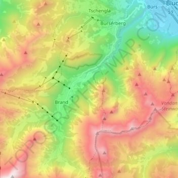
Mapa topográfico Brandnertal
Clique no mapa para exibir a altitude.
Obrigado por apoiar este site ❤️
Faça uma doação
Faça uma doação
Brandnertal
The Brandnertal is located in the southern part of Vorarlberg, in the far west of Austria. Adjacent to Switzerland, the Principality of Liechtenstein and Germany. In the immediate vicinity of the city of Bludenz starts the Brandnertal. From Bürs the valley rises, via Bürserberg to Brand, which is at an altitude of more than 1,000 m. The Schesaplana and the Lünersee, which lies at the foot of the highest peak of the Rätikon, form the end of the valley.
Obrigado por apoiar este site ❤️
Faça uma doação
Faça uma doação
Sobre este mapa
Nome: Mapa topográfico Brandnertal, altitude, relevo.
Local: Brandnertal, Brand, Bezirk Bludenz, Vorarlberg, Austria (47.06669 9.73463 47.15430 9.80918)
Altitude média: 1.572 m
Altitude mínima: 557 m
Altitude máxima: 2.773 m
Obrigado por apoiar este site ❤️
Faça uma doação
Faça uma doação