Geolocalizar

Mapa topográfico Sint Eustatius

Mapa interativo

Clique no mapa para exibir a altitude.

Sobre este mapa

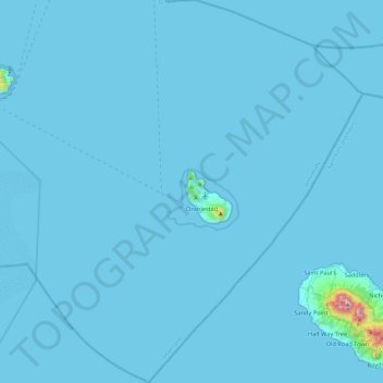
Nome: Mapa topográfico Sint Eustatius, altitude, relevo.

Local: Sint Eustatius, Netherlands (17.27673 -63.19861 17.72699 -62.78471)

Altitude média: 12 m

Altitude mínima: 0 m

Altitude máxima: 1.044 m

Sint Eustatius is 6 miles (10 km) long and up to 3 miles (5 km) wide. Topographically, the island is saddle-shaped, with the 602-meter-high dormant volcano Quill (Mount Mazinga), (from Dutch kuil, meaning 'pit'—originally referring to its crater) to the southeast and the smaller summits of Signal Hill/Little Mountain (or Bergje) and Boven Mountain to the northwest. The Quill crater is a popular tourist attraction on the island. The bulk of the island's population lives in the flat saddle between the two elevated areas, which forms the centre of the island.

Wikipedia (CC-BY-SA 3.0)

Outros mapas topográficos

Clique em um mapa para visualizar sua topografia, sua altitude e seu relevo.

Helmond

Netherlands > North Brabant

Helmond, North Brabant, Netherlands

Altitude média: 20 m

Dordrecht

Netherlands > South Holland

Dordrecht, South Holland, Netherlands

Altitude média: 1 m

Utrecht

Netherlands > Utrecht

Utrecht, Netherlands

Altitude média: 3 m

The Hague

Netherlands > South Holland

The Hague, South Holland, Netherlands

Altitude média: 2 m

Zoetermeer

Netherlands > South Holland > Zoetermeer

Zoetermeer, South Holland, Netherlands

Altitude média: -3 m

Saba

Netherlands

Saba, Netherlands

Altitude média: 2 m

Emmeloord

Netherlands > Flevoland

Emmeloord, Noordoostpolder, Flevoland, Netherlands

Altitude média: -3 m

Zeist

Netherlands > Utrecht > Zeist

Zeist, Utrecht, Netherlands

Altitude média: 8 m

Vaals

Netherlands > Limburg

Vaals, Limburg, Netherlands

Altitude média: 226 m

Het Loo

Netherlands > Overijssel > Wierden

Het Loo, Wierden, Overijssel, Netherlands, 7641 PP, Netherlands

Altitude média: 12 m

Zeewolde

Netherlands > Flevoland > Zeewolde

Zeewolde, Flevoland, Netherlands

Altitude média: -2 m

Zoute

Netherlands > Zeeland > Yerseke

Zoute, Yerseke, Reimerswaal, Zeeland, Netherlands, 4401 NG, Netherlands

Altitude média: -1 m

's-Hertogenbosch

Netherlands > North Brabant

's-Hertogenbosch, North Brabant, Netherlands

Altitude média: 4 m

Hoogerheide

Netherlands > North Brabant

Hoogerheide, Woensdrecht, North Brabant, Netherlands

Altitude média: 12 m

Sloten

Netherlands > North Holland > Amsterdam

Sloten, Amsterdam, North Holland, Netherlands, 1066 CZ, Netherlands

Altitude média: 0 m

Aruba

Netherlands

Aruba, Netherlands

Altitude média: 11 m

Rincon

Netherlands

Rincon, Bonaire, Netherlands

Altitude média: 40 m

Schagen

Netherlands > North Holland

Schagen, North Holland, Netherlands

Altitude média: 0 m

Curaçao

Netherlands

Curaçao, Curacao, Netherlands

Altitude média: 7 m

Alkmaar

Netherlands > North Holland

Alkmaar, North Holland, Netherlands

Altitude média: -2 m

Willemstad

Netherlands > Willemstad

Willemstad, Curacao, 80210, Netherlands

Altitude média: 8 m

Rotterdam

Netherlands > South Holland

Rotterdam, South Holland, Netherlands

Altitude média: 0 m

Philipsburg

Netherlands > Philipsburg

Philipsburg, Country of Sint Maarten, 721, Netherlands

Altitude média: 33 m

Groningen

Netherlands > Groningen > Groningen

Groningen, Netherlands, 9712HS, Netherlands

Altitude média: 2 m

Eindhoven

Netherlands > North Brabant > Eindhoven

Eindhoven, North Brabant, Netherlands, 5611EB, Netherlands

Altitude média: 21 m

Breda

Netherlands > North Brabant > Breda

Breda, North Brabant, Netherlands

Altitude média: 7 m

Oranjestad

Netherlands > Oranjestad

Oranjestad, Aruba, 000, Netherlands

Altitude média: 12 m

Nijmegen

Netherlands > Gelderland > Nijmegen

Nijmegen, Gelderland, Netherlands

Altitude média: 19 m

Hilversum

Netherlands > North Holland

Hilversum, North Holland, Netherlands

Altitude média: 5 m

Leeuwarden

Netherlands > Frisia > Leeuwarden

Leeuwarden, Frisia, Netherlands, 8911BR, Netherlands

Altitude média: 0 m

Zwijndrecht

Netherlands > South Holland > Zwijndrecht

Zwijndrecht, South Holland, Netherlands

Altitude média: 1 m

Tiel

Netherlands > Gelderland > Tiel

Tiel, Gelderland, Netherlands

Altitude média: 6 m

Kralendijk

Netherlands > Kralendijk

Kralendijk, Bonaire, Netherlands, 1234AB, Netherlands

Altitude média: 9 m

Limburg

Netherlands

Limburg, Netherlands

Altitude média: 49 m

Frisia

Netherlands > Frisia

Frisia, Netherlands

Altitude média: 1 m

Utrecht

Netherlands > Utrecht > Utrecht

Utrecht, Netherlands

Altitude média: 3 m

Zaandam

Netherlands > North Holland > Zaandam

Zaandam, Zaanstad, North Holland, Netherlands

Altitude média: 0 m

558

Netherlands > Zeeland > Kamperland

558, Kamperland, Noord-Beveland, Zeeland, Netherlands

Altitude média: 0 m

Drenthe

Netherlands > Drenthe

Drenthe, Netherlands

Altitude média: 9 m

Overijssel

Netherlands > Overijssel

Overijssel, Netherlands

Altitude média: 15 m

Spijkenisse

Netherlands > South Holland

Spijkenisse, Nissewaard, South Holland, Netherlands

Altitude média: 1 m

Amsterdam

Netherlands > North Holland

Amsterdam, North Holland, Netherlands

Altitude média: 0 m

Arnhem

Netherlands > Gelderland

Arnhem, Gelderland, Netherlands

Altitude média: 38 m

Zeeland

Netherlands > Zeeland

Zeeland, Netherlands

Altitude média: 1 m

Zwolle

Netherlands > Overijssel > Zwolle

Zwolle, Overijssel, Netherlands

Altitude média: 3 m

Gelderland

Netherlands

Gelderland, Netherlands

Altitude média: 14 m

Dok

Netherlands > Curacao > Dok

Dok, Curacao, Netherlands

Altitude média: 6 m

Venlo

Netherlands > Limburg

Venlo, Limburg, Netherlands

Altitude média: 32 m

Camping

Netherlands > Friesland > De Fryske Marren

Camping, De Fryske Marren, Friesland, Netherlands, 8493KN, Netherlands

Altitude média: -1 m

Reuver

Netherlands > Limburg > Beesel

Reuver, Beesel, Limburg, Netherlands

Altitude média: 30 m