
Mapa topográfico Hoogerheide
Mapa interativo
Clique no mapa para exibir a altitude.
Sobre este mapa
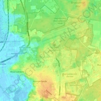
Nome: Mapa topográfico Hoogerheide, altitude, relevo.
Local: Hoogerheide, Woensdrecht, North Brabant, Netherlands (51.41396 4.29349 51.46680 4.36533)
Altitude média: 12 m
Altitude mínima: -3 m
Altitude máxima: 28 m
Outros mapas topográficos
Clique em um mapa para visualizar sua topografia, sua altitude e seu relevo.
's-Hertogenbosch
's-Hertogenbosch, North Brabant, Netherlands
Altitude média: 4 m
Eindhoven
Netherlands > North Brabant > Eindhoven
Eindhoven, North Brabant, Netherlands, 5611EB, Netherlands
Altitude média: 21 m
Mill
Netherlands > North Brabant > Mill en Sint Hubert
Mill, Mill en Sint Hubert, North Brabant, Netherlands
Altitude média: 14 m
Eindhoven
Netherlands > North Brabant > Eindhoven
Eindhoven, North Brabant, Netherlands
Altitude média: 20 m