
Faça uma doação
Mapa topográfico Benbrook Lake
Clique no mapa para exibir a altitude.
Faça uma doação
Benbrook Lake
Construction of Benbrook dam began in May 1947, and was practically completed when floodgates were closed and deliberate impoundment was begun in September 1952. The cost to build the lake was $14.5 million ($112 million in 2007 dollars). The rolled-earth embankment is 9,130 feet (2,783 m) in length, including the concrete spillway, and rises 130 feet (39.6 m) above the streambed to an elevation of 747 feet (227.7 m) above sea level. A pair of 6.5-foot (2.0 m) × 13-foot (4.0 m) sliding gates operated by electric cable hoists controls the floodwater releases through the 13-foot-diameter conduit (4.0 m) . Two 30-inch-diameter pipes (0.76 m) are provided for low-flow releases to maintain downstream river flows. The concrete spillway for uncontrolled releases is 500 feet (152 m) long, with a 100-foot notch (30 m) in its center.
Faça uma doação
Sobre este mapa
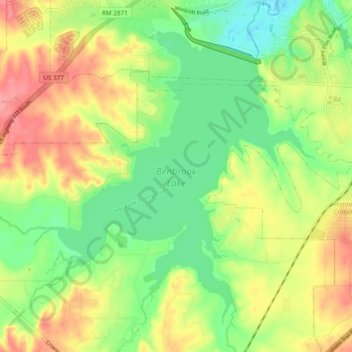
Nome: Mapa topográfico Benbrook Lake, altitude, relevo.
Altitude média: 228 m
Altitude mínima: 192 m
Altitude máxima: 271 m
Faça uma doação
Outros mapas topográficos
Clique em um mapa para visualizar sua topografia, sua altitude e seu relevo.