
Faça uma doação
Mapa topográfico Sienna
Clique no mapa para exibir a altitude.
Faça uma doação
Sobre este mapa
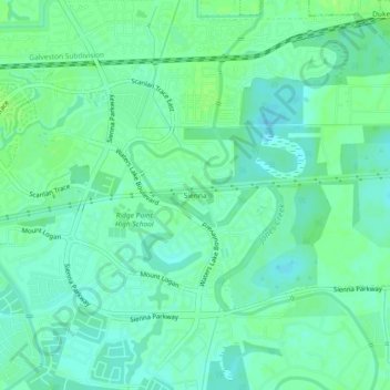
Nome: Mapa topográfico Sienna, altitude, relevo.
Local: Sienna, Fort Bend County, Texas, United States (29.46607 -95.52800 29.50607 -95.48800)
Altitude média: 20 m
Altitude mínima: 14 m
Altitude máxima: 25 m
Faça uma doação
Outros mapas topográficos
Clique em um mapa para visualizar sua topografia, sua altitude e seu relevo.
Sugar Land
United States > Texas > Fort Bend County
Sugar Land is located in northeast Fort Bend County, 20 miles (32 km) southwest of downtown Houston. It is bordered by Houston to the northeast, and by Stafford, Missouri City, and Meadows Place to the east. According to the United States Census Bureau, the city of Sugar Land has a total area of 34.0 square…
Altitude média: 24 m
Faça uma doação
Brazos Bend State Park
United States > Texas > Fort Bend County > Alvin
Brazos Bend State Park occupies land bordering the Brazos River and includes within its boundaries low-lying areas left over from the River's previous meanderings. Pre-Columbian inhabitants included a series of Native American groups, most notably the Karankawa. The land passed through a variety of landowners'…
Altitude média: 17 m
Faça uma doação
Faça uma doação
Sugar Land
United States > Texas > Fort Bend County
Sugar Land is located in northeast Fort Bend County, 20 miles (32 km) southwest of downtown Houston. It is bordered by Houston to the northeast, and by Stafford, Missouri City, and Meadows Place to the east. According to the United States Census Bureau, the city of Sugar Land has a total area of 42.9 square…
Altitude média: 24 m
Faça uma doação
Sienna (Brazos River) Park
United States > Texas > Fort Bend County > Missouri City
Altitude média: 20 m
Faça uma doação