Geolocalizar

Mapa topográfico Edmonton

Clique no mapa para exibir a altitude.

Edmonton

Edmonton is on the North Saskatchewan River, at an elevation of 671 m (2,201 ft). It is North America's northernmost city with a population over one million. It is south of Alberta's geographic centre, which is near the Hamlet of Fort Assiniboine. The terrain in and around Edmonton is generally flat to gently rolling, with ravines and deep river valleys, such as the North Saskatchewan River valley. The Canadian Rockies are west of Edmonton and about 220 km (140 mi) to the southwest.

Wikipedia (CC-BY-SA 3.0)

Sobre este mapa

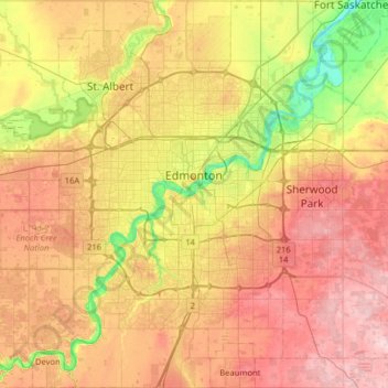
Nome: Mapa topográfico Edmonton, altitude, relevo.

Local: Edmonton, Alberta, Canada (53.33726 -113.71384 53.71626 -113.27148)

Altitude média: 690 m

Altitude mínima: 600 m

Altitude máxima: 783 m

Outros mapas topográficos

Clique em um mapa para visualizar sua topografia, sua altitude e seu relevo.

Canmore

Canada > Alberta > Town of Canmore

Elevation Place opened in April 2013 as Canmore's new recreation facility. Construction of the facility began in 2012 to replace the Canmore Recreation Centre (the community's old facility). The facility offers an 8-lane 25m lap pool, a world class climbing wall developed by Walltopia, two cardio rooms, a…

Altitude média: 1.565 m

Banff

Canada > Alberta > Banff > Banff

Banff is a town within Banff National Park in Alberta, Canada. It is located in Alberta's Rockies along the Trans-Canada Highway, approximately 126 km (78 mi) west of Calgary and 58 km (36 mi) east of Lake Louise. At 1,400 to 1,630 m (4,590 to 5,350 ft) above sea level, Banff is the community with the second…

Altitude média: 1.615 m

St. Albert

Canada > Alberta > St. Albert

Altitude média: 681 m

Lake Louise

Canada > Alberta > Improvement District No. 9

Lake Louise is a hamlet within Banff National Park in Alberta, Canada. Named after Princess Louise, Duchess of Argyll, it lies in Alberta's Rockies on the Bow River, 3 km (1.9 mi) northeast of the lake that shares its name. Initially settled in 1884 as an outpost for the Canadian Pacific Railway, Lake Louise…

Altitude média: 1.617 m

Nose Hill Park

Canada > Alberta > Calgary

Names currently associated with topographical features in and near Nose Hill Park reflect the impact of the European newcomers and European trade goods on the Peigan. For example, Spy Hill, the westward extension of Nose Hill, derived its present name from the aboriginal practice of communicating with distant…

Altitude média: 1.174 m

Lethbridge

Canada > Alberta > Lethbridge

Its high elevation of 929 m (3,047.9 ft) and close proximity to the Rocky Mountains provides Lethbridge with cooler summers than other locations in the Canadian Prairies. These factors protect the city from strong northwest and southwest winds and contribute to frequent chinook winds during the winter.…

Altitude média: 918 m

Crowsnest Pass

Canada > Alberta > Crowsnest Pass

Altitude média: 1.410 m

Calgary

Canada > Alberta > Calgary

Altitude média: 1.106 m

Wimborne

Canada > Alberta > Kneehill County

Wimborne is a hamlet in southern Alberta, Canada within Kneehill County. It is located approximately 58 km (36 mi) southeast of Red Deer. It has an elevation of 975 m (3,199 ft).

Altitude média: 962 m

Red Deer

Canada > Alberta > Red Deer

Altitude média: 918 m

Grande Prairie

Canada > Alberta > Grande Prairie

Grande Prairie is located just north of the 55th parallel north, and is 465 km (289 mi) northwest of Edmonton, lying at an elevation of 669 m (2,195 ft) above sea level. The city is surrounded by farmland to the north, east, and west. To the south lies a vast boreal forest with aspen, tamarack, lodgepole pine,…

Altitude média: 668 m

Pembina River

Canada > Alberta > Yellowhead County

Altitude média: 1.140 m

Cochrane

Canada > Alberta > Town of Cochrane > Cochrane

Cochrane is situated at the base of Big Hill in the Bow River Valley. It sits at an elevation of 1,186 m (3,891 ft). The town is intersected by Highway 1A and Highway 22. Cochrane has a reputation for its western culture, which can easily be felt when one wanders the streets (particularly Main Street). The…

Altitude média: 1.205 m

La Glace

Canada > Alberta > County of Grande Prairie

La Glace is a hamlet in northern Alberta, Canada within the County of Grande Prairie No. 1. It is located along Highway 59 between Sexsmith and Valhalla Centre and has an elevation of 735 metres (2,411 ft).

Altitude média: 738 m

Bragg Creek

Canada > Alberta

Altitude média: 1.384 m

Barrhead

Canada > Alberta

Altitude média: 733 m

Caroline

Canada > Alberta

Altitude média: 1.066 m

Red Deer (city)

Canada > Alberta

Altitude média: 924 m

Maskwacis

Canada > Alberta > Ponoka County

Altitude média: 802 m

Airdrie

Canada > Alberta > Airdrie

Altitude média: 1.112 m

Rumsey

Canada > Alberta > Starland County

Altitude média: 845 m

Okotoks

Canada > Alberta > Town of Okotoks

Altitude média: 1.096 m

Drumheller (town)

Canada > Alberta

Altitude média: 857 m

Olds

Canada > Alberta > Town of Olds

Altitude média: 1.027 m

Drumheller

Canada > Alberta > Drumheller

Altitude média: 763 m

Cold Lake

Canada > Alberta > Cold Lake

Altitude média: 550 m

Horseshoe Canyon

Canada > Alberta > Kneehill County

Altitude média: 857 m

Saddle Lake

Canada > Alberta > Smoky Lake County

Altitude média: 620 m

William Hawrelak Park

Canada > Alberta > Edmonton

Altitude média: 649 m

Peace River

Canada > Alberta > Peace River

Physiographically, the Town of Peace River lies within the Peace River Formation, a stratigraphical unit of middle Albian age in the Western Canadian Sedimentary Basin. The area developed on sediments of the former lake bottom of Glacial Lake Peace, which covered most of the areas in the region that were below…

Altitude média: 433 m

Nordegg

Canada > Alberta > Clearwater County

Nordegg has a subarctic climate (Dfc) which can be considered a subalpine climate due to its altitude with locations on the same latitude having warmer climates. Summers are mild, with a few warm days sprinkled in here and there, while winters are cold and snowy.

Altitude média: 1.475 m

Beaverdam Lake

Canada > Alberta > Cardston County

Altitude média: 1.420 m

Gabriel Lake

Canada > Alberta > Lacombe County

Altitude média: 953 m

Richdale

Canada > Alberta > Special Area No. 2

Altitude média: 771 m

Chain Lakes

Canada > Alberta > Ponoka County

Altitude média: 858 m

Nordegg

Canada > Alberta > Clearwater County

Nordegg has a subarctic climate (Dfc) which can be considered a subalpine climate due to its altitude with locations on the same latitude having warmer climates. Summers are mild, with a few warm days sprinkled in here and there, while winters are cold and snowy.

Altitude média: 1.475 m

Olds

Canada > Alberta > Town of Olds

Altitude média: 1.027 m

Okotoks

Canada > Alberta > Town of Okotoks

Altitude média: 1.096 m

Bow River

Canada > Alberta > Canmore

Altitude média: 1.353 m

Northern Lights

Canada > Alberta

Altitude média: 530 m

Mount Ball

Canada > Alberta > Improvement District No. 9

Altitude média: 2.621 m

Mount K2

Canada > Alberta > Improvement District No. 12

Altitude média: 2.549 m

Halfmoon Lake

Canada > Alberta > Thorhild County

Altitude média: 631 m

Wandering River

Canada > Alberta > Athabasca County

Altitude média: 575 m

Mount Columbia

Canada > Alberta > Improvement District No. 12

Mount Columbia is a mountain located in the Winston Churchill Range of the Rocky Mountains. It is the highest point in Alberta, Canada, and is second only to Mount Robson for height and topographical prominence in the Canadian Rockies. It is located on the border between Alberta and British Columbia on the…

Altitude média: 2.841 m

Pine Lake

Canada > Alberta > Red Deer County

Altitude média: 914 m

Carrot Creek

Canada > Alberta > Yellowhead County

Altitude média: 871 m

Vermilion

Canada > Alberta > Town of Vermilion

Altitude média: 616 m

Stirling (village)

Canada > Alberta

Altitude média: 1.017 m

Savanna Park

Canada > Alberta > Calgary

Altitude média: 1.095 m

Hythe

Canada > Alberta > County of Grande Prairie

Altitude média: 747 m

Kevisville

Canada > Alberta > Red Deer County

Altitude média: 985 m

Bow Island

Canada > Alberta > Town of Bow Island

Altitude média: 795 m

Golden Spike

Canada > Alberta > Parkland County

Altitude média: 714 m

Rosemary

Canada > Alberta > County of Newell

Altitude média: 747 m

Sedgewick

Canada > Alberta > Town of Sedgewick

Altitude média: 670 m

Ormsby Park

Canada > Alberta > Edmonton

Altitude média: 688 m

Erskine

Canada > Alberta > County of Stettler

Altitude média: 812 m

Shaughnessy

Canada > Alberta > Lethbridge County

Altitude média: 907 m

Erith

Canada > Alberta > Yellowhead County

Altitude média: 985 m

Moraine Lake

Canada > Alberta > Improvement District No. 9

Moraine Lake is a snow and glacially fed alpine lake in Banff National Park, 14 kilometres (8.7 mi) outside the village of Lake Louise, Alberta, Canada. It is situated in the Valley of the Ten Peaks, at an elevation of approximately 1,884 metres (6,181 ft). The lake has a surface area of 50 hectares (120…

Altitude média: 2.101 m

Coalhurst

Canada > Alberta > Lethbridge County

Altitude média: 918 m

Cochrane Lake

Canada > Alberta > Rocky View County

Altitude média: 1.292 m