Geolocalizar

Mapa topográfico Kirkcaldy

Clique no mapa para exibir a altitude.

Kirkcaldy

Towards the end of the 16th century, a detailed assessment on the size of the townscape was carried out. The first estimate of the parish population in 1639 was between 3,000 and 3,200 and around 3,400 by 1691. At the beginning of the 18th century, the population declined. A census by Webster's Topographical Dictionary of Scotland in 1755, recorded an estimate of 2,296 in the parish. By the time of the first nationwide UK census in 1801, the population had risen to 3,248. The population of the burgh was recorded as 4,785 in the 1841 Census, and had risen to 34,079 by 1901. By the time of the 1951 Census, the figure stood at 49,050.

Wikipedia (CC-BY-SA 3.0)

Sobre este mapa

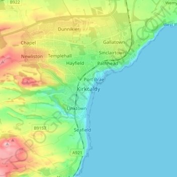
Nome: Mapa topográfico Kirkcaldy, altitude, relevo.

Local: Kirkcaldy, Fife, Scotland, KY1 1JA, United Kingdom (56.07102 -3.19823 56.15102 -3.11823)

Altitude média: 50 m

Altitude mínima: -2 m

Altitude máxima: 185 m

Outros mapas topográficos

Clique em um mapa para visualizar sua topografia, sua altitude e seu relevo.

Loch Fitty

United Kingdom > Scotland > Fife > Kelty

Altitude média: 152 m

Dunfermline

United Kingdom > Scotland > Fife > Dunfermline

Altitude média: 80 m

Aberdour

United Kingdom > Scotland > Fife

Altitude média: 77 m

Oakley

United Kingdom > Scotland > Fife

Altitude média: 89 m

Loch Gelly

United Kingdom > Scotland > Fife > Lochgelly

Altitude média: 124 m

Kinghorn

United Kingdom > Scotland > Fife

Altitude média: 38 m

Dunfermline

United Kingdom > Scotland > Fife

Altitude média: 114 m

North Queensferry

United Kingdom > Scotland > Fife

Altitude média: 9 m

Rosyth

United Kingdom > Scotland > Fife

Altitude média: 23 m

Auchtertool

United Kingdom > Scotland > Fife

Altitude média: 113 m

Burntisland

United Kingdom > Scotland > Fife

Altitude média: 49 m

Townhill Wood

United Kingdom > Scotland > Fife > Dunfermline > Townhill

Altitude média: 138 m

Cameron Reservoir

United Kingdom > Scotland > Fife

Altitude média: 156 m

Inchkeith

United Kingdom > Scotland > Fife > Burntisland

Altitude média: 1 m

Kinghorn Loch

United Kingdom > Scotland > Fife > Kinghorn

Altitude média: 64 m

Inchcolm

United Kingdom > Scotland > Fife

Altitude média: 1 m

Loch Ore

United Kingdom > Scotland > Fife > Glencraig > Lochcraig

Altitude média: 114 m

Isle of May

United Kingdom > Scotland > Fife

Altitude média: 1 m

Silver Sands

United Kingdom > Scotland > Fife > Aberdour

Altitude média: 34 m

Kinghorn

United Kingdom > Scotland > Fife

Altitude média: 38 m

Mossmorran Pond

United Kingdom > Scotland > Fife > Cowdenbeath

Altitude média: 137 m

East Burn

United Kingdom > Scotland > Fife > Kirkcaldy

Altitude média: 44 m

Denett Burn

United Kingdom > Scotland > Fife > Anstruther

Altitude média: 45 m

Inverkeithing

United Kingdom > Scotland > Fife

Topographically, Inverkeithing is situated on a raised terrace sloping down towards Inverkeithing Bay, which cuts in to the south of the town, separating it from the North Queensferry peninsula. Its medieval centre lay along High Street and Church Street, but the town has since expanded to encompass areas to…

Altitude média: 28 m

Rosyth

United Kingdom > Scotland > Fife

Altitude média: 23 m

Burntisland

United Kingdom > Scotland > Fife

Altitude média: 49 m

Dunfermline

United Kingdom > Scotland > Fife

Altitude média: 114 m