
Obrigado por apoiar este site ❤️
Faça uma doação
Faça uma doação
Mapa topográfico Carbonville
Clique no mapa para exibir a altitude.
Obrigado por apoiar este site ❤️
Faça uma doação
Faça uma doação
Sobre este mapa
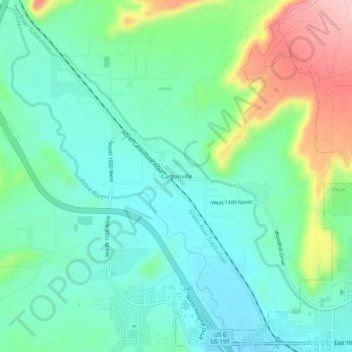
Nome: Mapa topográfico Carbonville, altitude, relevo.
Local: Carbonville, Carbon County, Utah, 84591, United States (39.59996 -110.85433 39.63996 -110.81433)
Altitude média: 1.741 m
Altitude mínima: 1.686 m
Altitude máxima: 1.881 m
Obrigado por apoiar este site ❤️
Faça uma doação
Faça uma doação
Outros mapas topográficos
Clique em um mapa para visualizar sua topografia, sua altitude e seu relevo.
Scofield Reservoir
United States > Utah > Carbon County
Scofield Reservoir is a 2,815-acre (11.39 km2) reservoir impounded by Scofield Dam, in Carbon County, Utah. Located on the Price River, a tributary of the Green River, Scofield Reservoir is adjacent to northernmost boundary of the Manti–La Sal National Forest. The reservoir sits at an elevation of 7,618 feet…
Altitude média: 2.435 m