
Faça uma doação
Mapa topográfico Scofield Reservoir
Clique no mapa para exibir a altitude.
Faça uma doação
Scofield Reservoir
Scofield Reservoir is a 2,815-acre (11.39 km2) reservoir impounded by Scofield Dam, in Carbon County, Utah. Located on the Price River, a tributary of the Green River, Scofield Reservoir is adjacent to northernmost boundary of the Manti–La Sal National Forest. The reservoir sits at an elevation of 7,618 feet (2,322 m), on the northern edge of the Wasatch Plateau. Utah State Route 96 runs along the western shoreline.
Faça uma doação
Sobre este mapa
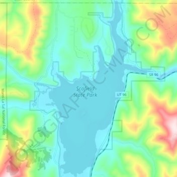
Nome: Mapa topográfico Scofield Reservoir, altitude, relevo.
Local: Scofield Reservoir, Carbon County, Utah, United States (39.74814 -111.17269 39.81400 -111.11997)
Altitude média: 2.435 m
Altitude mínima: 2.307 m
Altitude máxima: 2.804 m
Faça uma doação
Outros mapas topográficos
Clique em um mapa para visualizar sua topografia, sua altitude e seu relevo.