
Faça uma doação
Mapa topográfico Oakley
Clique no mapa para exibir a altitude.
Faça uma doação
Oakley
Oakley is located 45 miles (72 km) east of Salt Lake City on SR-32, in the Kamas Valley. With an elevation of 6,500 feet (2,000 m), it is a gateway to the Uinta Mountains. Scenic route Weber Canyon Road follows the Weber River to its headwaters; it also follows the Smith and Morehouse Creek to its reservoir in its own scenic canyon 15 miles (24 km) from Oakley. The towns of Marion, Kamas, and Peoa are its neighbors, and the Weber River flows nearby.
Faça uma doação
Sobre este mapa
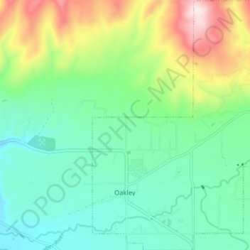
Nome: Mapa topográfico Oakley, altitude, relevo.
Local: Oakley, Summit County, Utah, United States (40.70209 -111.31011 40.75652 -111.24288)
Altitude média: 2.047 m
Altitude mínima: 1.901 m
Altitude máxima: 2.390 m
Faça uma doação
Outros mapas topográficos
Clique em um mapa para visualizar sua topografia, sua altitude e seu relevo.
Park City
United States > Utah > Summit County > Park City
In the summertime, many valley residents of the Wasatch Front visit the town to escape high temperatures. Park City is usually cooler than Salt Lake City as it lies mostly higher than 7,000 feet (2,100 m) above sea level, while Salt Lake City is situated at an elevation of about 4,300 feet (1,300 m).
Altitude média: 2.315 m
Faça uma doação
Faça uma doação