
Faça uma doação
Mapa topográfico Manhattan
Clique no mapa para exibir a altitude.
Faça uma doação
Sobre este mapa
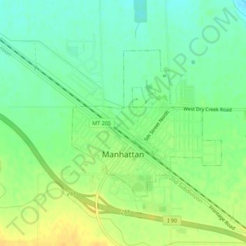
Nome: Mapa topográfico Manhattan, altitude, relevo.
Local: Manhattan, Gallatin County, Montana, United States (45.85076 -111.34219 45.86683 -111.31855)
Altitude média: 1.294 m
Altitude mínima: 1.281 m
Altitude máxima: 1.308 m
Faça uma doação
Outros mapas topográficos
Clique em um mapa para visualizar sua topografia, sua altitude e seu relevo.
Gallatin Gateway
United States > Montana > Gallatin County
Gallatin Gateway is a census-designated place (CDP) in Gallatin County, Montana, United States. As of the 2020 census, Gallatin Gateway had a population of 967. Elevation is 4,953 ft (1,510 m).
Altitude média: 1.519 m
Faça uma doação
Faça uma doação
Bozeman
United States > Montana > Gallatin County > Bozeman
Bozeman is located at an elevation of 4,820 feet (1,470 m). The Bridger Mountains are to the north-northeast, the Tobacco Root Mountains to the west-south-west, the Big Belt Mountains and Horseshoe Hills to the northwest, the Hyalite Peaks of the northern Gallatin Range to the south and the Spanish Peaks of…
Altitude média: 1.679 m