
Faça uma doação
Mapa topográfico Gallatin Gateway
Clique no mapa para exibir a altitude.
Faça uma doação
Gallatin Gateway
Gallatin Gateway is a census-designated place (CDP) in Gallatin County, Montana, United States. As of the 2020 census, Gallatin Gateway had a population of 967. Elevation is 4,953 ft (1,510 m).
Faça uma doação
Sobre este mapa
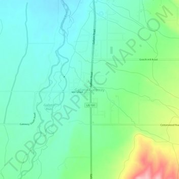
Nome: Mapa topográfico Gallatin Gateway, altitude, relevo.
Local: Gallatin Gateway, Gallatin County, Montana, United States (45.57161 -111.21742 45.61161 -111.17742)
Altitude média: 1.519 m
Altitude mínima: 1.479 m
Altitude máxima: 1.627 m
Faça uma doação
Outros mapas topográficos
Clique em um mapa para visualizar sua topografia, sua altitude e seu relevo.
Big Sky
United States > Montana > Gallatin County
Big Sky is characterized by its dramatic and diverse topography, which forms part of the northern Rocky Mountains. The area features an elevation that ranges from around 5,500 feet in the valleys to more than 11,000 feet at its peaks, including the notable Lone Peak. This mountainous terrain is interspersed…
Altitude média: 2.435 m
Bozeman
United States > Montana > Gallatin County
Bozeman is located at an elevation of 4,820 feet (1,470 m). The Bridger Mountains are to the north-northeast, the Tobacco Root Mountains to the west-southwest, the Big Belt Mountains and Horseshoe Hills to the northwest, the Hyalite Peaks of the northern Gallatin Range to the south and the Spanish Peaks of the…
Altitude média: 1.495 m
Faça uma doação
Faça uma doação
Bozeman
United States > Montana > Gallatin County
Bozeman is located at an elevation of 4,820 feet (1,470 m). The Bridger Mountains are to the north-northeast, the Tobacco Root Mountains to the west-southwest, the Big Belt Mountains and Horseshoe Hills to the northwest, the Hyalite Peaks of the northern Gallatin Range to the south and the Spanish Peaks of the…
Altitude média: 1.495 m
Big Sky
United States > Montana > Gallatin County
Big Sky is located close to the Yellowstone National Park along the western edge of Gallatin County and eastern edge of Madison County, on U.S. Highway 191. It is approximately midway between West Yellowstone and Bozeman, being around 45 miles (72 km) by road from each. It sits within the Madison Range, with…
Altitude média: 2.439 m
Faça uma doação
Bozeman
United States > Montana > Gallatin County
Bozeman is located at an elevation of 4,820 feet or 1,470 metres. The Bridger Mountains are to the north-northeast, the Tobacco Root Mountains to the west-south-west, the Big Belt Mountains and Horseshoe Hills to the northwest, the Hyalite Peaks of the northern Gallatin Range to the south and the Spanish Peaks…
Altitude média: 1.495 m