
Faça uma doação
Mapa topográfico Highbridge Park
Clique no mapa para exibir a altitude.
Faça uma doação
Highbridge Park
The north and south wings respectively contain the women's and men's locker rooms and are nearly identical. Both have nine windows separated by eight brick pilasters. The stone capitals of the pilasters line up with the lintels of the windows. Ramps lead from the extreme ends of each wing. The ground slopes down northward, so that the northern wing is at a higher elevation above the ground than the southern wing. The eastern facade is similar to the western facade, except that it contains entrances to both genders' respective locker rooms, as well as a bronze clock hanging from the architrave. A cellar is below the northern wing.
Faça uma doação
Sobre este mapa
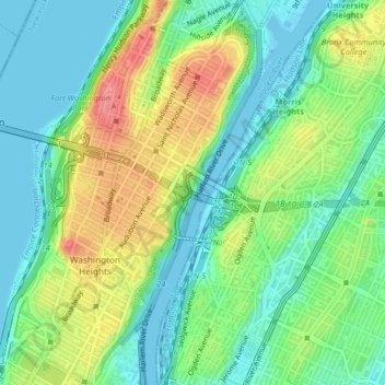
Nome: Mapa topográfico Highbridge Park, altitude, relevo.
Altitude média: 30 m
Altitude mínima: -3 m
Altitude máxima: 85 m
Faça uma doação
Outros mapas topográficos
Clique em um mapa para visualizar sua topografia, sua altitude e seu relevo.
Morningside Park
United States > New York > New York County > New York
Dutch settlers occupied Manhattan in the early 17th century and called the area around Morningside Park Vredendal, meaning 'peaceful dale'. The lowlands to the east were called Flacken by the Dutch, and were later translated to "Flats" in English. The land to the east was not settled initially because of its…
Altitude média: 20 m
Faça uma doação
Faça uma doação
Hunter’s Point South Waterfront Park
United States > New York > New York County > New York
Altitude média: 5 m