
Faça uma doação
Mapa topográfico Charles Mound
Clique no mapa para exibir a altitude.
Faça uma doação
Sobre este mapa
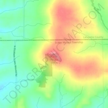
Nome: Mapa topográfico Charles Mound, altitude, relevo.
Altitude média: 326 m
Altitude mínima: 285 m
Altitude máxima: 373 m
Faça uma doação
Outros mapas topográficos
Clique em um mapa para visualizar sua topografia, sua altitude e seu relevo.
Faça uma doação
Stockton
United States > Illinois > Jo Daviess County
The village water tower sits on a ridge at elevation 1,105 ft (337 m) that rises to 1,120 ft (340 m) to the west at the village limits. To the northwest the same ridge line continues where U.S. Route 20 crests at 1,077 ft (328 m) just to the west. This ridge line continues for 3 miles to the northwest to…
Altitude média: 301 m
Faça uma doação
Scales Mound
United States > Illinois > Jo Daviess County
Scales Mound is located in a region of the U.S. Midwest known as the Driftless Area, so called because it escaped glaciation during the last ice age. It covers parts of Illinois, Wisconsin, Minnesota and Iowa. The Illinois section is mostly limited to Jo Daviess County and small parts of Whiteside and Carroll…
Altitude média: 294 m