
Obrigado por apoiar este site ❤️
Faça uma doação
Faça uma doação
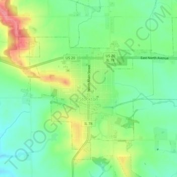
Mapa topográfico Stockton
Clique no mapa para exibir a altitude.
Obrigado por apoiar este site ❤️
Faça uma doação
Faça uma doação
Stockton
The village water tower sits on a ridge at elevation 1,105 ft (337 m) that rises to 1,120 ft (340 m) to the west at the village limits. To the northwest the same ridge line continues where U.S. Route 20 crests at 1,077 ft (328 m) just to the west. This ridge line continues for 3 miles to the northwest to Benton Mound (1,204 ft; 367 m ), the second highest peak in Illinois.
Obrigado por apoiar este site ❤️
Faça uma doação
Faça uma doação
Sobre este mapa
Nome: Mapa topográfico Stockton, altitude, relevo.
Altitude média: 301 m
Altitude mínima: 267 m
Altitude máxima: 356 m
Obrigado por apoiar este site ❤️
Faça uma doação
Faça uma doação
Outros mapas topográficos
Clique em um mapa para visualizar sua topografia, sua altitude e seu relevo.