
Mapa topográfico Oberwiesenthal
Mapa interativo
Clique no mapa para exibir a altitude.
Sobre este mapa
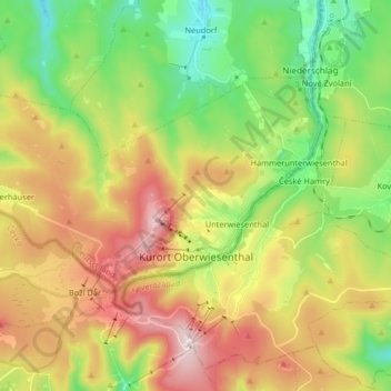
Nome: Mapa topográfico Oberwiesenthal, altitude, relevo.
Local: Oberwiesenthal, Erzgebirgskreis, Saxony, 09484, Germany (50.40402 12.85948 50.46706 13.02269)
Altitude média: 928 m
Altitude mínima: 677 m
Altitude máxima: 1.249 m
Oberwiesenthal lies in the county of Erzgebirgskreis, on the border with the Czech Republic that follows the course of the Pöhlbach stream as far as Bärenstein (10 km northeast). The highest elevation in the borough is the Fichtelberg (sometimes called the Großer Fichtelberg or Great Fichtelberg) which, at 1,215 m above NN, is the highest mountain in Saxony.
Outros mapas topográficos
Clique em um mapa para visualizar sua topografia, sua altitude e seu relevo.
08289
Germany > Saxony > Erzgebirgskreis > Schneeberg
08289, Griesbach, Schneeberg, Erzgebirgskreis, Saxony, Germany
Altitude média: 505 m
Ehrenfriedersdorf
Germany > Saxony > Erzgebirgskreis
Ehrenfriedersdorf, Erzgebirgskreis, Saxony, 09427, Germany
Altitude média: 582 m
Tannenberg
Germany > Saxony > Erzgebirgskreis
Tannenberg, Verwaltungsgemeinschaft Geyer, Erzgebirgskreis, Saxony, Germany
Altitude média: 590 m
Aue
Germany > Saxony > Erzgebirgskreis
Aue, Aue-Bad Schlema, Erzgebirgskreis, Saxony, 08280, Germany
Altitude média: 465 m
Olbernhau
Germany > Saxony > Erzgebirgskreis
Olbernhau, Erzgebirgskreis, Saxony, 09526, Germany
Altitude média: 612 m
Niederdorf
Germany > Saxony > Erzgebirgskreis
Niederdorf, Stollberg/Erzgeb., Erzgebirgskreis, Saxony, Germany
Altitude média: 413 m
Kühnhaide
Germany > Saxony > Erzgebirgskreis > Marienberg > Kühnhaide
Kühnhaide, Marienberg, Erzgebirgskreis, Saxony, 09496, Germany
Altitude média: 760 m
Andreasberg
Germany > Saxony > Erzgebirgskreis > Auerbach
Andreasberg, Auerbach, Burkhardtsdorf, Erzgebirgskreis, Saxony, 09390, Germany
Altitude média: 546 m