
Faça uma doação
Mapa topográfico Providence Canyon
Clique no mapa para exibir a altitude.
Faça uma doação
Sobre este mapa
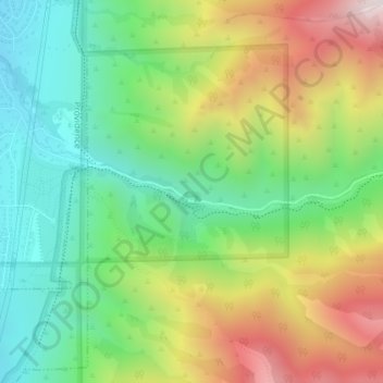
Nome: Mapa topográfico Providence Canyon, altitude, relevo.
Altitude média: 1.829 m
Altitude mínima: 1.491 m
Altitude máxima: 2.361 m
Faça uma doação
Outros mapas topográficos
Clique em um mapa para visualizar sua topografia, sua altitude e seu relevo.
Logan
United States > Utah > Cache County
The city lies near the eastern edge of Cache Valley on the western slopes of the Bear River Mountains. Mount Logan rises to an elevation of 9,710 feet (2,960 m) immediately to the east, and south of Logan Canyon. The eastern portions of the city are constructed on top of shelf-like "benches", late Pleistocene…
Altitude média: 1.498 m
Faça uma doação
Faça uma doação
Logan
United States > Utah > Cache County
The city lies near the eastern edge of Cache Valley on the western slopes of the Bear River Mountains. Mount Logan rises to an elevation of 9,710 feet (2,960 m) immediately to the east, and south of Logan Canyon. The eastern portions of the city are atop shelf-like "benches", late Pleistocene sedimentary…
Altitude média: 1.498 m
Faça uma doação