

Mapa topográfico Mont-Albert
Clique no mapa para exibir a altitude.
Mont-Albert
The ghost town of Saint-Octave-de-l'Avenir is about 18 kilometres (11 mi) south-southeast of Cap-Chat, at an altitude of 380 metres (1,250 ft). It was formed in 1932 as part of the Vautrin Settlement Plan to encourage colonization of Gaspésie's interior and intended to bring relief during the Great Depression of the 1930s. The settlement was named after founding priest Louis-Octave Caron (1879–1942) and a hopeful outlook of the future (avenir is French for "future"). It grew to 1200 residents in 1937 but then declined until it was abandoned in 1971. Only summer camps remain.
Sobre este mapa
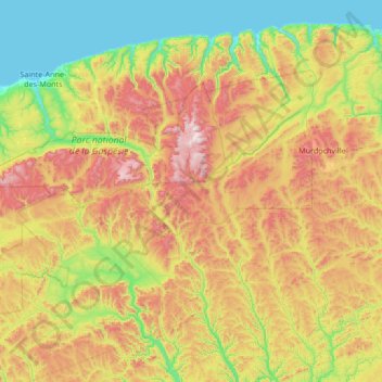
Nome: Mapa topográfico Mont-Albert, altitude, relevo.
Altitude média: 427 m
Altitude mínima: -2 m
Altitude máxima: 1.260 m
Outros mapas topográficos
Clique em um mapa para visualizar sua topografia, sua altitude e seu relevo.

Madeleine-Centre
Canada > Quebec > La Haute-Gaspésie > Sainte-Madeleine-de-la-Rivière-Madeleine
Altitude média: 72 m

Rivière-la-Madeleine
Canada > Quebec > La Haute-Gaspésie > Sainte-Madeleine-de-la-Rivière-Madeleine
Altitude média: 46 m
Notre Dame Mountains
Canada > Quebec > La Haute-Gaspésie > Mont-Albert
The Chic-Choc Mountains are one of the primary subranges of the Notre Dame Mountains. They are located in the northeastern part of the Gaspé Peninsula and are home to the tallest mountain in the range, Mont Jacques-Cartier, with an elevation of 1,268 m (4,160 ft). The other major subsection of the Notre Dame…
Altitude média: 1.128 m