
Obrigado por apoiar este site ❤️
Faça uma doação
Faça uma doação
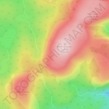
Mapa topográfico Notre Dame Mountains
Clique no mapa para exibir a altitude.
Obrigado por apoiar este site ❤️
Faça uma doação
Faça uma doação
Notre Dame Mountains
The Chic-Choc Mountains are one of the primary subranges of the Notre Dame Mountains. They are located in the northeastern part of the Gaspé Peninsula and are home to the tallest mountain in the range, Mont Jacques-Cartier, with an elevation of 1,268 m (4,160 ft). The other major subsection of the Notre Dame Mountains is the Massif du Sud, which is found in the southern part of the range, southeast of Quebec City, and reaches an elevation of 915 m (3,002 ft).
Obrigado por apoiar este site ❤️
Faça uma doação
Faça uma doação
Sobre este mapa
Nome: Mapa topográfico Notre Dame Mountains, altitude, relevo.
Altitude média: 1.128 m
Altitude mínima: 925 m
Altitude máxima: 1.276 m
Obrigado por apoiar este site ❤️
Faça uma doação
Faça uma doação