
Faça uma doação
Mapa topográfico Ellesmere
Clique no mapa para exibir a altitude.
Faça uma doação
Sobre este mapa
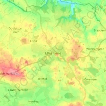
Nome: Mapa topográfico Ellesmere, altitude, relevo.
Local: Ellesmere, Shropshire, England, SY12 0EQ, United Kingdom (52.86742 -2.93387 52.94742 -2.85387)
Altitude média: 94 m
Altitude mínima: 46 m
Altitude máxima: 155 m
Faça uma doação
Outros mapas topográficos
Clique em um mapa para visualizar sua topografia, sua altitude e seu relevo.
Clungunford
United Kingdom > England > Shropshire
Clungunford lies at an elevation of between 130m and 145m above sea level.
Altitude média: 181 m
Shrewsbury
United Kingdom > England > Shropshire > Shrewsbury
Shrewsbury is about 14 miles (23 km) west of Telford, 43 miles (69 km) west of Birmingham and the West Midlands Conurbation, and about 153 miles (246 km) north-west of the capital, London. More locally, the town is to the east of Welshpool, with Bridgnorth and Kidderminster to the south-east. The border with…
Altitude média: 69 m
Faça uma doação