
Faça uma doação
Mapa topográfico Shrewsbury
Clique no mapa para exibir a altitude.
Faça uma doação
Shrewsbury
Shrewsbury is about 14 miles (23 km) west of Telford, 43 miles (69 km) west of Birmingham and the West Midlands Conurbation, and about 153 miles (246 km) north-west of the capital, London. More locally, the town is to the east of Welshpool, with Bridgnorth and Kidderminster to the south-east. The border with Wales is 9 miles (14 km) to the west. The town centre is partially built on a hill whose elevation is, at its highest, 246 feet (75 m) above sea level. The longest river in the UK, the River Severn, flows through the town, forming a meander around its centre. The town is subject to flooding from the river.
Faça uma doação
Sobre este mapa
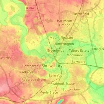
Nome: Mapa topográfico Shrewsbury, altitude, relevo.
Local: Shrewsbury, Shropshire, West Midlands, England, United Kingdom (52.68019 -2.81432 52.75498 -2.70122)
Altitude média: 69 m
Altitude mínima: 19 m
Altitude máxima: 103 m
Faça uma doação