
Faça uma doação
Mapa topográfico Lewisville
Clique no mapa para exibir a altitude.
Faça uma doação
Lewisville
Lewisville is at 33°2′18″N 97°0′22″W / 33.03833°N 97.00611°W / 33.03833; -97.00611 (33.038316, −97.006232) at an elevation of about 550 feet (170 m). It has a total area of 42.5 square miles (110 km2), of which 6.1 sq mi (16 km2) is covered by water. It lies at the southern end of Denton County and the northern end of the Dallas–Fort Worth metroplex, in the eastern part of the Cross Timbers region of Texas between the Texas Blackland Prairies and the Grand Prairie. Vista Ridge, a small plateau, is in the southeast corner of Lewisville, and the lowest part of Denton County, at 484 feet (148 m), is found in the city. Lewisville sits above the Barnett Shale, a geological formation containing a large quantity of natural shale gas.
Faça uma doação
Sobre este mapa
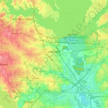
Nome: Mapa topográfico Lewisville, altitude, relevo.
Local: Lewisville, Denton County, Texas, United States (32.98512 -97.04566 33.10035 -96.86587)
Altitude média: 160 m
Altitude mínima: 129 m
Altitude máxima: 202 m
Faça uma doação
Outros mapas topográficos
Clique em um mapa para visualizar sua topografia, sua altitude e seu relevo.
Clear Creek Natural Heritage Center
United States > Texas > Denton County > Denton
Altitude média: 173 m
Faça uma doação
Lewisville
United States > Texas > Denton County > Lewisville
Lewisville is at 33°2′18″N 97°0′22″W / 33.03833°N 97.00611°W / 33.03833; -97.00611 (33.038316, −97.006232) at an elevation of about 550 feet (170 m). It has a total area of 42.47 square miles (110.0 km2), of which 36.4 sq mi (94 km2) is land. It lies at the southern end of Denton County…
Altitude média: 174 m
Faça uma doação
Lakewood Village
United States > Texas > Denton County > Lakewood Village > Lakewood Village
Altitude média: 163 m