
Faça uma doação
Mapa topográfico Fort Worth
Clique no mapa para exibir a altitude.
Faça uma doação
Sobre este mapa
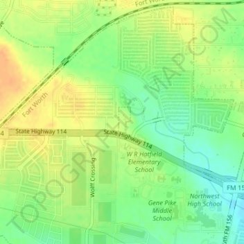
Nome: Mapa topográfico Fort Worth, altitude, relevo.
Local: Fort Worth, Denton County, Texas, United States (33.03477 -97.32511 33.03814 -97.32355)
Altitude média: 213 m
Altitude mínima: 195 m
Altitude máxima: 228 m
Faça uma doação
Outros mapas topográficos
Clique em um mapa para visualizar sua topografia, sua altitude e seu relevo.
Little Elm
United States > Texas > Denton County
According to the U.S. Census Bureau, it has a total area of 18.6 square miles (48.3 km2), of which 14.6 square miles (37.7 km2) is land and 4.1 square miles (10.5 km2), or 21.83%, is covered by water. Little Elm has an average elevation of 545 feet above sea level.
Altitude média: 171 m
Denton
United States > Texas > Denton County
Denton is on the northern edge of the Dallas–Fort Worth metropolitan area. These three cities form the area known as the "Golden Triangle of North Texas". According to the United States Census Bureau, the city has an area of 89.316 square miles (231.33 km2), of which 87.952 square miles (227.79 km2) is land…
Altitude média: 195 m
Faça uma doação
Faça uma doação
Faça uma doação
Faça uma doação
Lewisville
United States > Texas > Denton County
Lewisville is at 33°2′18″N 97°0′22″W / 33.03833°N 97.00611°W / 33.03833; -97.00611 (33.038316, −97.006232) at an elevation of about 550 feet (170 m). It has a total area of 42.5 square miles (110 km2), of which 6.1 sq mi (16 km2) is covered by water. It lies at the southern end of Denton…
Altitude média: 160 m
Faça uma doação
Faça uma doação
Faça uma doação
Faça uma doação
Faça uma doação
Faça uma doação
Denton
United States > Texas > Denton County
Denton is located on the northern edge of the Dallas–Fort Worth metropolitan area. These three cities form the area known as the "Golden Triangle of North Texas." According to the United States Census Bureau, the city has a total area of 89.316 square miles (231.33 km2), of which 87.952 square miles (227.79…
Altitude média: 195 m
Lewisville
United States > Texas > Denton County > Lewisville
Lewisville is at 33°2′18″N 97°0′22″W / 33.03833°N 97.00611°W / 33.03833; -97.00611 (33.038316, −97.006232) at an elevation of about 550 feet (170 m). It has a total area of 42.47 square miles (110.0 km2), of which 36.4 sq mi (94 km2) is land. It lies at the southern end of Denton County…
Altitude média: 174 m
Faça uma doação
Lakewood Village
United States > Texas > Denton County > Lakewood Village > Lakewood Village
Altitude média: 163 m
Faça uma doação