
Obrigado por apoiar este site ❤️
Faça uma doação
Faça uma doação
Mapa topográfico Kennecott River
Clique no mapa para exibir a altitude.
Obrigado por apoiar este site ❤️
Faça uma doação
Faça uma doação
Sobre este mapa
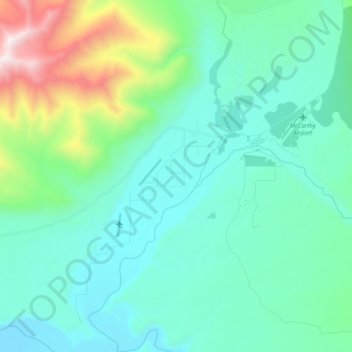
Nome: Mapa topográfico Kennecott River, altitude, relevo.
Local: Kennecott River, Copper River, Alaska, United States (61.37645 -143.01759 61.47050 -142.93649)
Altitude média: 622 m
Altitude mínima: 322 m
Altitude máxima: 1.920 m
Obrigado por apoiar este site ❤️
Faça uma doação
Faça uma doação
Outros mapas topográficos
Clique em um mapa para visualizar sua topografia, sua altitude e seu relevo.
Kennicott
United States > Alaska > Copper River
Topographic map showing the location of the Erie, Jumbo, Mother Lode, Bonanza and Glacier Mines in relation to Kennecott. Note the aerial tramways and haulage tunnels.
Altitude média: 789 m