
Mapa topográfico Colne
Clique no mapa para exibir a altitude.
Colne
Pendle Leisure Trust runs the Pendle Leisure Centre next to the railway station. The facility has two swimming pools, a fitness centre and gymnasium, sauna and sports hall. In summer 2013, the outdoor all-weather pitch was replaced by Urban Altitude. This outdoor aerial assault course is the first of its kind to be built in the UK in an urban location. It includes high and low rope courses, up to 42 ft off the ground, a 60m Zip-Wire, Leap of Faith, Power Fan Free-fall, Jacobs Ladder and Climbing Wall.
Sobre este mapa
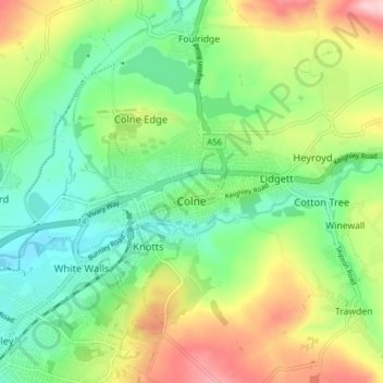
Nome: Mapa topográfico Colne, altitude, relevo.
Local: Colne, Borough of Pendle, Lancashire, England, United Kingdom (53.84131 -2.20491 53.87446 -2.12707)
Altitude média: 197 m
Altitude mínima: 122 m
Altitude máxima: 328 m
Outros mapas topográficos
Clique em um mapa para visualizar sua topografia, sua altitude e seu relevo.
Colne Water
United Kingdom > England > Lancashire > Borough of Pendle > Laneshaw Bridge
Altitude média: 202 m
Lad Law (Boulsworth Hill)
United Kingdom > England > Lancashire > Borough of Pendle
Altitude média: 409 m