
Faça uma doação
Mapa topográfico Blue Ridge Mountains
Clique no mapa para exibir a altitude.
Faça uma doação
Blue Ridge Mountains
Although the term "Blue Ridge" is sometimes applied exclusively to the eastern edge or front range of the Appalachian Mountains, the geological definition of the Blue Ridge province extends westward to the Ridge and Valley area, encompassing the Great Smoky Mountains, the Great Balsams, the Roans, the Blacks, and other mountain ranges. In North Carolina, two lower elevation ranges to the east, referred to as foothills, are also often included as "spurs" of the Blue Ridge: the Brushy Mountains and the South Mountains. In Virginia the Southwest Mountains are an anticlinal range that similarly parallels the Blue Ridge.
Faça uma doação
Sobre este mapa
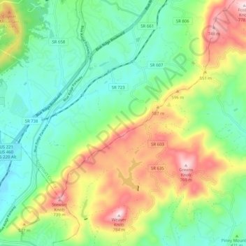
Nome: Mapa topográfico Blue Ridge Mountains, altitude, relevo.
Altitude média: 460 m
Altitude mínima: 290 m
Altitude máxima: 774 m
Faça uma doação
Outros mapas topográficos
Clique em um mapa para visualizar sua topografia, sua altitude e seu relevo.