
Faça uma doação
Mapa topográfico Lithia
Clique no mapa para exibir a altitude.
Faça uma doação
Sobre este mapa
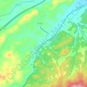
Nome: Mapa topográfico Lithia, altitude, relevo.
Local: Lithia, Botetourt County, Virginia, United States (37.45819 -79.77143 37.49819 -79.73143)
Altitude média: 342 m
Altitude mínima: 265 m
Altitude máxima: 483 m
Faça uma doação
Outros mapas topográficos
Clique em um mapa para visualizar sua topografia, sua altitude e seu relevo.
Blue Ridge Mountains
United States > Virginia > Botetourt County
Although the term "Blue Ridge" is sometimes applied exclusively to the eastern edge or front range of the Appalachian Mountains, the geological definition of the Blue Ridge province extends westward to the Ridge and Valley area, encompassing the Great Smoky Mountains, the Great Balsams, the Roans, the Blacks,…
Altitude média: 460 m
Faça uma doação
Blue Ridge Mountains
United States > Virginia > Botetourt County
Although the term "Blue Ridge" is sometimes applied exclusively to the eastern edge or front range of the Appalachian Mountains, the geological definition of the Blue Ridge province extends westward to the Ridge and Valley area, encompassing the Great Smoky Mountains, the Great Balsams, the Roans, the Blacks,…
Altitude média: 460 m
Blue Ridge Mountains
United States > Virginia > Botetourt County
Although the term "Blue Ridge" is sometimes applied exclusively to the eastern edge or front range of the Appalachian Mountains, the geological definition of the Blue Ridge province extends westward to the Ridge and Valley area, encompassing the Great Smoky Mountains, the Great Balsams, the Roans, the Blacks,…
Altitude média: 461 m
Faça uma doação
Blue Ridge Mountains
United States > Virginia > Botetourt County
Although the term "Blue Ridge" is sometimes applied exclusively to the eastern edge or front range of the Appalachian Mountains, the geological definition of the Blue Ridge province extends westward to the Ridge and Valley area, encompassing the Great Smoky Mountains, the Great Balsams, the Roans, the Blacks,…
Altitude média: 461 m