
Obrigado por apoiar este site ❤️
Faça uma doação
Faça uma doação
Mapa topográfico Beersheba Springs
Clique no mapa para exibir a altitude.
Obrigado por apoiar este site ❤️
Faça uma doação
Faça uma doação
Sobre este mapa
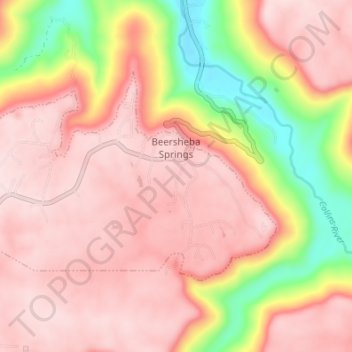
Nome: Mapa topográfico Beersheba Springs, altitude, relevo.
Altitude média: 478 m
Altitude mínima: 276 m
Altitude máxima: 579 m
Obrigado por apoiar este site ❤️
Faça uma doação
Faça uma doação
Outros mapas topográficos
Clique em um mapa para visualizar sua topografia, sua altitude e seu relevo.
Monteagle
United States > Tennessee > Grundy County > Monteagle
The town straddles a narrow stretch of the Cumberland Plateau known colloquially as "Monteagle Mountain". This stretch of the plateau is approximately 2 miles (3 km) wide, with steep drop-offs to the northwest and southeast. Monteagle lies at an elevation of just under 2,000 feet (610 m) above sea level. By…
Altitude média: 566 m
South Cumberland Recreation Area
United States > Tennessee > Grundy County > Beersheba Springs
Altitude média: 533 m
Obrigado por apoiar este site ❤️
Faça uma doação
Faça uma doação